Autodesk XPSWMM: Integrated 1D/2D modeling for stormwater and wastewater management

What is Autodesk XPSWMM?
Autodesk XPSWMM is an integrated 1D/2D modeling solution for stormwater and wastewater management supporting urban planning, growth, and flood mitigation efforts.
Create 1D and 2D hydrodynamic models for detailed analysis of stormwater, wastewater, and combined sewer systems.
Simulate rainfall runoff processes in urban watersheds to understand and manage water flow.
Analyze water quality to mitigate undesirable overflows.

Predict water flow in any environment

Improve efficiency with an integrated modeling experience
Predict water flow in any environment
Improve efficiency with an integrated modeling experience
Features
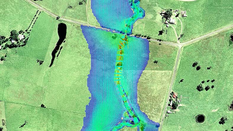
River and floodplain management
Simulate urban floodplains. Analyze flow and pollutant transport and create accurate hazard maps.
Combine hydrology and hydraulics
Analyze stormwater and sanitary and combined sewer systems. Simulate runoff, drainage, and pollutants.
Proactively address system issues
Manage CSOs and SSOs, track infiltration and inflow, and use real-time controls.
Conduct scenario analysis
Run parallel simulations, compare scenarios, evaluate rainfall events, and assess green infrastructure.
Thorough capital planning
Maintain efficient capacity management programs for watersheds or stormwater and sanitary systems.
Efficient modeling
Import GIS, CAD, and HEC-RAS data. Create/import land surfaces, generate cross sections, and compute flow.
Autodesk XPSWMM resources
CUSTOMER STORY
What if Hurricane Harvey had hit San Antonio?
HDR combines data from ICMLive, HEC-RAS, HEC-HMS, and XPSWMM to model the impacts of a superstorm.
BLOG
Get the most from your XPSWMM files
Take advantage of cloud computing by importing XPSWMM models into InfoWorks ICM with the XP Importer.

CASE STUDY
Improved decision making with more precise models
ISG relied on XPSWMM for many years, giving them the baseline data they needed to expand to new tools.


Questions? We have answers.
Autodesk XPSWMM is a software application used for simulating hydrologic and hydraulic systems, aiding in stormwater and wastewater management, floodplain mapping, and river modeling. It enables the design and analysis of urban drainage systems, sanitary sewer networks, and natural watercourses, helping predict and mitigate flooding, optimize infrastructure, and ensure regulatory compliance. Autodesk XPSWMM supports integrated water resources management by evaluating watershed hydrology, pollutant transport, and the impacts of land-use changes and climate change. It is an essential tool for engineers, planners, and environmental professionals focused on sustainable and resilient water resource management.
Autodesk XPSWMM is used by civil and environmental engineers, urban planners, government agencies, municipalities, consulting firms, academic researchers, utilities, and construction companies. These professionals and organizations rely on Autodesk XPSWMM to design, analyze, and manage stormwater, wastewater, and natural water systems. They use the software to predict flooding, optimize infrastructure, ensure regulatory compliance, and support sustainable water resource management and development planning.
Autodesk XPSWMM is available in two product tiers: XPSWMM Sewer and XPSWMM Complete.
XPSWMM Sewer includes:
1D modeling for sanitary sewer networks (excludes river analysis and 2D flood capabilities)
XPSWMM Complete includes:
Integrated 1D/2D modeling for stormwater and sanitary sewer networks
Capabilities previously available in Innovyze XPStorm
All former Innovyze add-on licenses for GPU and multiple domains
Contact us for more information and pricing for these offerings.
Products you can trust
From payment flexibility to always-on support, expect excellence.

