Wet ponds and infiltration basins are a common feature of Sustainable Drainage Systems (SuDS) and are widely used in urban drainage design to manage stormwater and rainwater runoff, as well as promote sustainable drainage practices.
Ponds and infiltration basins are two of the most effective strategies in sustainable drainage design, offering multiple benefits beyond simple stormwater control. By capturing runoff from impervious surfaces and either storing it for gradual release or allowing it to soak back into the ground, these systems reduce flood risks, improve water quality, and recharge groundwater supplies.
At the same time, they create valuable green spaces that support biodiversity and enhance community resilience. Let’s dig into how ponds and infiltration basins work, their advantages and limitations, key design considerations, and how modern digital tools can help engineers, planners, and property owners integrate them into sustainable drainage systems for both urban and transportation projects.
The importance of Sustainable Drainage Systems (SuDS)
Modern cities and suburbs face an ongoing challenge: how to manage stormwater in ways that reduce flooding, improve water quality, and restore some of the natural processes lost to urbanization. That’s where Sustainable Drainage Systems (SuDS) come in.
Unlike traditional “pipe-and-convey” infrastructure, SuDS are designed to slow, store, and filter rainfall close to where it lands. By mimicking nature, these systems help water soak into the ground, filter pollutants, and recharge groundwater, rather than overwhelming storm sewers. For engineers, SuDS provide a more resilient and multifunctional approach to stormwater control. For property owners and residents, they can mean greener neighborhoods, reduced flood risks, and cleaner local waterways.
SuDS is the term most often used in the UK. In the US, the same principles are often referred to as Low Impact Drainage Strategies (LIDS) or Best Management Practices (BMPs).
SuDS or LIDS are not a single solution, but a collection of strategies—from swales and porous pavement to infiltration basins and ponds. Among these, ponds and infiltration basins are two of the most effective tools for combining water storage, treatment, and environmental benefits.
Ponds vs. infiltration basins: What’s the difference?
Although often discussed together, ponds and infiltration basins are distinct in design and function. In short: infiltration basins focus on groundwater recharge and treatment, while ponds emphasize storage and surface water benefits.
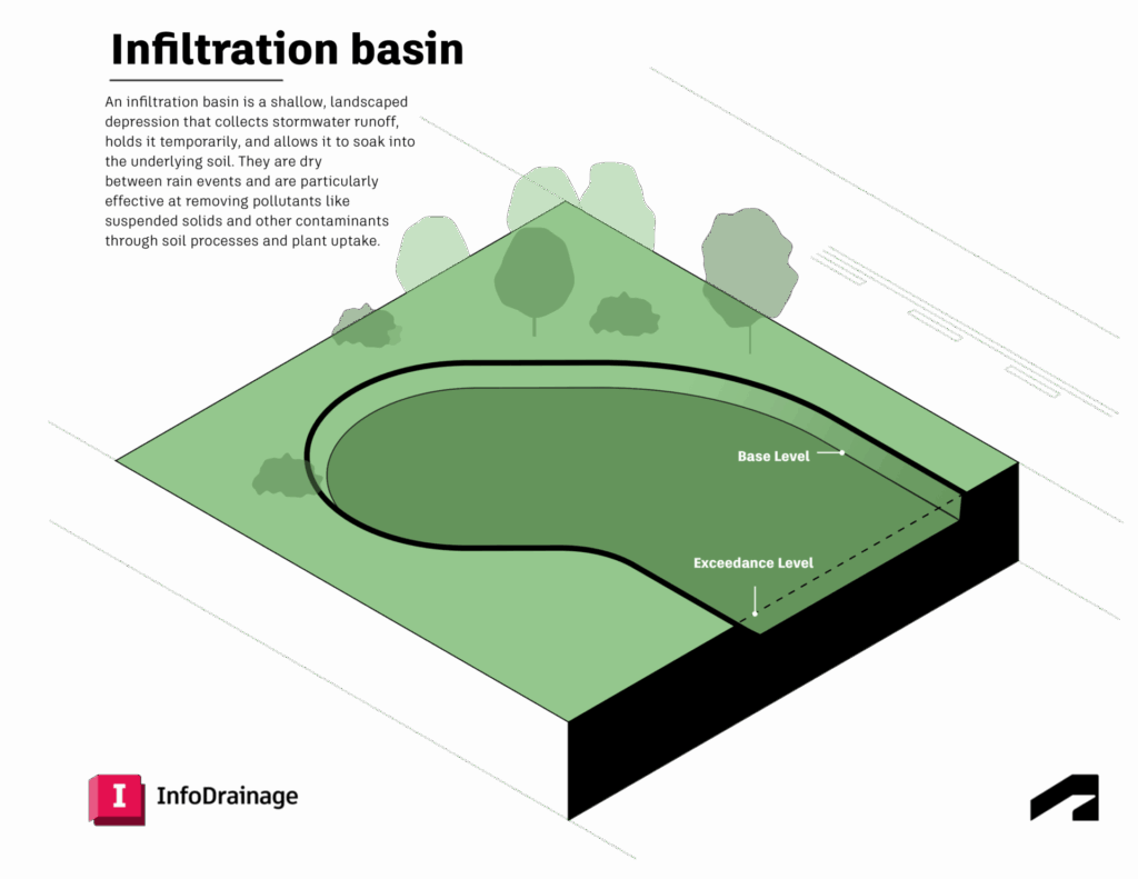
What are infiltration basins?
These are shallow, man-made depressions designed to capture runoff and allow it to soak into the ground. They may also be called attenuation basins or detention basins. They are not intended to hold water permanently but instead to slowly infiltrate stormwater through permeable soils, recharging the groundwater table. Infiltration basins are particularly effective at removing pollutants such as sediments, nutrients, metals, oil and grease, and pathogens.
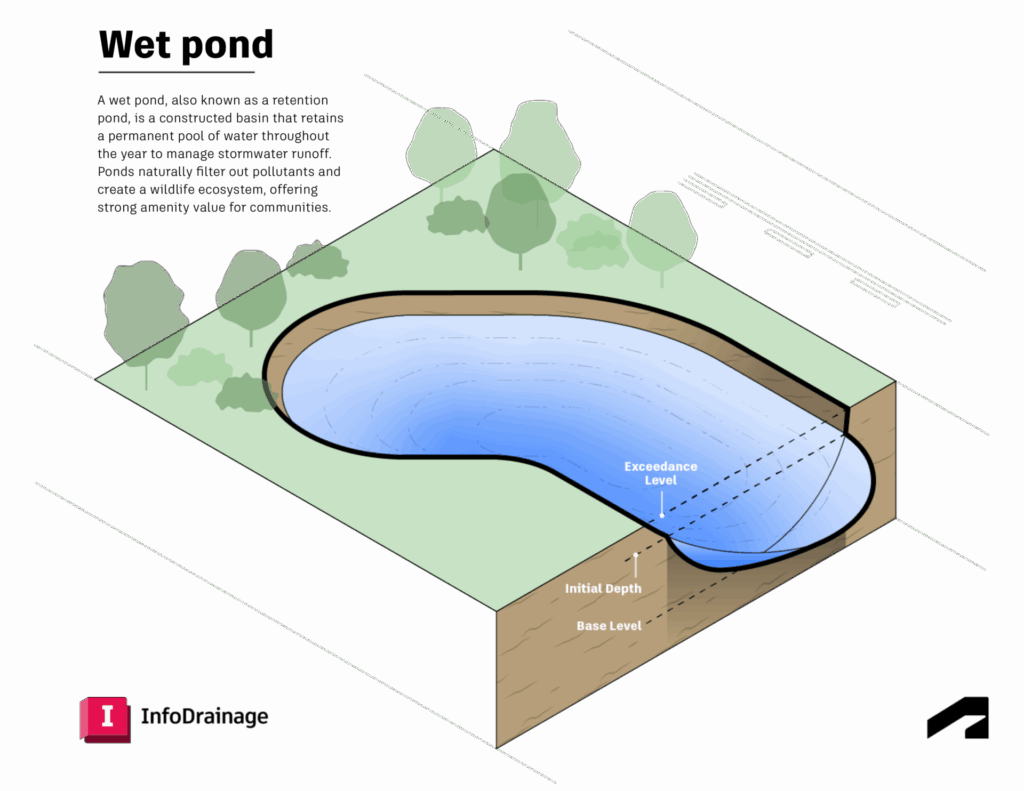
What are wet ponds?
In contrast, wet ponds – sometimes also called retention basins – maintain a permanent pool of water. During storms, the water level rises temporarily, then gradually returns to its baseline. Beyond flood control, ponds provide recreational and ecological benefits, supporting aquatic life and creating opportunities for public open space. Because ponds become their own ecosystem, they offer countless additional envirnomental benefits, both to local communities and to the planet.
Why include ponds and infiltration basins in drainage design?
Ponds and infiltration basins play vital roles in flood management, water quality protection, biodiversity, and groundwater recharge:
- Flood prevention: These systems temporarily store runoff from hard surfaces and release it gradually, reducing peak flow rates that can overwhelm drainage networks and cause downstream flooding.
- Improved water quality: Vegetation, soil, and natural filtration processes remove sediments, nutrients, and pollutants before water is released or infiltrated, improving the quality of the water released downstream.
- Groundwater recharge: Infiltration basins allow water to percolate through soil layers, replenishing aquifers and supporting long-term water supply.
- Biodiversity and amenity: Properly designed ponds and basins provide habitats for birds, amphibians, and pollinators, while also enhancing green space in urban areas.
- Urban cooling: Open water bodies and vegetated drainage features can help moderate local temperatures, a valuable co-benefit in cities facing heat island effects.
- Cost efficiency: In many cases, infiltration basins require relatively low investment compared to traditional infrastructure. Construction typically involves excavation and grading, making them an affordable post-construction control measure for stormwater.
For engineers, these are reliable, multi-functional assets while, for communities, they mean fewer floods, healthier water, and greener public spaces.
Advantages and disadvantages of ponds and infiltration basins
When selecting between ponds and infiltration basins, designers should weigh both benefits and limitations.
Ponds
Advantages:
- Long-term water storage and potential reuse
- Creation of wildlife habitats
- Can serve as community amenities or landscape features
Disadvantages:
- Safety concerns may require fencing or restricted access
- Standing water can create maintenance and mosquito issues
Infiltration basins
Advantages:
- Simple to design and operate with low maintenance needs
- Highly effective at pollutant removal
- Generally robust and fail-safe if soils are suitable
Disadvantages:
- Require large surface areas and permeable soils
- Do not remove all dissolved contaminants, such as salts
- Improper drainage can lead to odor or mosquito problems
Key design considerations of ponds and infiltration basins
The success of ponds and infiltration basins depends heavily on site-specific conditions and careful engineering:
- Soil permeability: This is perhaps the most critical factor for infiltration basins. Ideal soils infiltrate at rates between 0.5–3 inches per hour, with limited clay content to ensure both drainage and pollutant removal.
- Water table separation: To avoid contamination, designs should maintain at least 4 feet between the basin bottom and seasonal high water table levels.
- Drawdown time: Infiltration basins should drain fully within 24–72 hours to cut down on mosquito breeding and maintain capacity for future storms.
- Sediment and pretreatment: Sediment traps or swales upstream can reduce clogging and extend the system’s lifespan.
- Sizing and setbacks: Proper dimensions are essential for function and compliance, with safe setbacks from structures and utilities.
- Maintenance: Regular inspections, vegetation management, and sediment removal are required to keep systems effective.
By addressing these considerations, engineers can design basins and ponds that function effectively over decades, not just a few seasons.
How do engineers typically design such ponds? Our customers rely on InfoDrainage software, which has a special focus on sustainable drainage design. You can go into more details of how the software calculates everything in the InfoDrainage help documentation.
Integrating ponds with other SuDS
Rarely do ponds or basins operate in isolation. They are typically used alongside upstream features such as swales and rain gardens. They work best as part of a treatment train that combines multiple SuDS elements:
- Swales: Vegetated channels that slow runoff and provide pretreatment
- Rain garden: A stormwater management design that uses natural materials and processes to collect and filter runoff from impermeable surfaces such as streets, driveways, and sidewalks.
- Porous pavement: Man-made surfaces that allow rainwater to infiltrate directly where it falls
- Infiltration trenches: Rock-filled excavations that promote percolation into surrounding soils
- Cellular storage systems: Underground tanks that hold and release stormwater gradually
- Soakaways: Pits or trenches that hold water that are often filled with plastic crates.
- Bioretention systems: Sometimes called bioswales or bioretention cells (and sometimes rain gardens, although they are semantically different)
This integrated approach maximizes pollutant removal, reduces maintenance burdens, and builds resilience into stormwater infrastructure. InfoDrainage software can link each of these features together to provide a robust model of a project site’s drainage capabilities.
Designing ponds with digital tools
Modern drainage design requires balancing environmental goals, regulatory compliance, and cost. Advanced tools like Autodesk InfoDrainage, Civil 3D, and InfraWorks can help streamline this process:
- InfoDrainage provides powerful hydrodynamic modeling to simulate interactions between drainage components and validate design performance under varied storm scenarios.
- Civil 3D integrates site grading, drainage networks, and basin sizing directly into civil design workflows, ensuring accuracy and efficiency. The software has a direct integration with InfoDrainage, so they are increasingly being used in conjunction.
- InfraWorks enables engineers to conduct early-stage drainage studies, visualize ponding areas, and evaluate SuDS alternatives in the context of broader infrastructure projects. This software is often added to the mix to create high-quality visualizations for stakeholders and clients.
Together, these tools help designers analyze, refine, and optimize ponds and infiltration basins — reducing reliance on spreadsheets, improving collaboration, and accelerating approvals.
The importance of analysis and simulation
When researchers have attempted to quantify the performance and benefits of ponds and infiltration basins, the results have varied widely, based on the climate and geography of the area and the permeability of the soil. Results for a basin in New Orleans, Louisiana will be significantly different than for a basin in Denver, Colorado or Edinburgh, Scotland.
That’s part of what makes the analysis and simulation tools in InfoDrainage so important. They enable you to:
- Analyze and calculate rainfall and runoff for your specific geographic location using real-time data – based on accepted rainfall and runoff methods from around the globe
- Identify overland flow patterns and understand ponding and channeling on your site surface using the Machine Learning Deluge tool
- Use detailed hydraulic analysis to reduce the risk of flooding downstream
Regulations and compliance
While the advantages of ponds and basins make them valuable in their own right, they also help you meet local sustainability and development regulations. InfoDrainage provides robust tools that enable you streamline compliance. You can generate drainage reports in the styles and formats you need for design approval, exposing all of the available inputs, outputs, simulation results, design results, and calculated values in one table. These reports can be customized for local regulations and requirements in a number of languages and units.
Special applications of ponds in transportation projects
Drainage for roads, highways, and rail projects poses unique challenges. In these contexts, ponds and infiltration basins can play a key role in preventing flooding, maintaining safety, and reducing runoff impacts.
With InfoDrainage and Civil 3D, engineers can model runoff volumes, identify likely ponding areas using the Deluge tool, and test multiple design alternatives. In addition, InfoDrainage has a built-in FHWA culvert analysis tool that simplifies compliance with USDOT requirements. For professionals, this means faster project delivery and more resilient infrastructure that meets sustainability goals.
If you want to explore the intricacies of drainage design workflows for transportation projects – including rail, roads, and highways – check out the Autodesk University class InfoDrainage for Transportation Projects: From Concept to Detailed Design. It shows you a workflow that facilitates the interaction and data exchange between InfoDrainage and Civil 3D without using spreadsheets, with a particular emphasis on using the Machine Learning Deluge tool in InfoDrainage.
Practical approaches to sustainable drainage
Ponds and infiltration basins are not just practical solutions for stormwater management, they are essential tools for creating sustainable, resilient, and livable communities. By slowing runoff, filtering pollutants, recharging aquifers, and enhancing biodiversity, they bridge the gap between engineering performance and environmental stewardship.
When designed thoughtfully, supported by digital modeling tools, and integrated with other SuDS practices, ponds and infiltration basins can help cities and neighborhoods thrive in the face of climate change and urban growth.
Learn more about designing wet ponds and infiltration basins
If you are focused on designing sustainable drainage features, check out these free courses and Autodesk University classes, which share case studies and workflows for designing ponds and infiltration basins:
- Navigating Drainage Design: A Flood of Solutions with InfraWorks, Civil 3D, and InfoDrainage: Get technical instruction about the entire drainage design process, from pre-project planning to detailed design, and learn how to use the automatic catchment delineation tools within Civil 3D for the creation of sub-catchments.
- Navigating Stormwater: How VHB Overcame Drainage Challenges Using InfoDrainage: Discover how a leading engineering firm transformed stormwater management with InfoDrainage, with a focus on using sophisticated simulation tools in InfoDrainage.
- Case studies and proof points: Explore how others have shaped sustainable drainage solutions for their area, climate, and infrastructure goals.
- Integrating InfoDrainage with Civil 3D: Get help with your integration and explore resources to simplify the process and bring more precise hydraulic results to your site design.
- InfoDrainage training: Get an in-depth introduction to InfoDrainage, including how to calculate runoff amounts, design a pond, simulate performance, and optimize designs.
Get started designing sustainable drainage
We have a full guide to sustainable drainage design principles, with articles and illustrations that we encourage you to use in presentations or whenever you need to convince stakeholders why they should build green instead of pouring more concrete. Ready to get designing?
- Download a 30-day free trial of InfoDrainage – no credit card required. (Are you a student or educator? You may be eligible to use this software for free.)
- Download the comprehensive Guide to Representing SuDS in InfoDrainage in accordance with the SuDS Manual Ciria 753.
- Dig into the InfoDrainage Technical Information Hub and examine how the software conforms to industry standards.