 Trevor English
If you work on drainage design in Civil 3D, you now have more options than you did just a few years ago. Autodesk InfoDrainage provides a purpose-built environment for drainage design and hydraulic analysis, while Autodesk Drainage Tools for Civil 3D bring drainage analysis workflows directly into Civil 3D. And many longtime Civil 3D users may still be familiar with Storm and Sanitary Analysis (SSA), Autodesk’s legacy drainage analysis application.
So which one should you use?
The short answer is that InfoDrainage and the Drainage Tools in Civil 3D serve different but complementary needs, while SSA is now primarily relevant to legacy workflows.
In this post, we’ll give you a background of how we’re approaching drainage design here at Autodesk, what the new drainage capabilities, powered by InfoDrainage in Civil 3D are, how it’s similar and different from InfoDrainage, and ultimately what you can expect for the future of drainage design solutions from the Autodesk portfolio.
We even have a handy feature comparison chart for you – both as an image and as a simple table. 👇
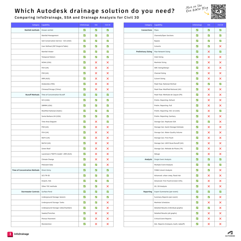
| Category | Capability | InfoDrainage | SSA | Civil 3D |
|---|---|---|---|---|
| Rainfall methods | Known rainfall | ✓ | ✓ | ✓ |
| Rainfall Management | ✓ | ✓ | ✓ | |
| Soil Conservation Service – SCS (USA) | ✓ | ✓ | ✓ | |
| User Defined (IDF Single & Table) | ✓ | ✓ | ✓ | |
| Rainfall Viewer | ✓ | ✓ | ✓ | |
| Temporal Pattern | ✓ | ✓ | ✓ | |
| NOAA (USA) | ✓ | ✕ | ✕ | |
| FEH (UK) | ✓ | ✕ | ✕ | |
| FSR (UK) | ✓ | ✕ | ✕ | |
| ARR (AUS) | ✓ | ✕ | ✕ | |
| Desbordes (FRA) | ✓ | ✕ | ✕ | |
| Chinese/Chicago (China) | ✓ | ✕ | ✕ | |
| Runoff Methods | Time of Concentration Runoff | ✓ | ✓ | ✓ |
| SCS (USA) | ✓ | ✓ | ✓ | |
| SWMM (USA) | ✓ | ✓ | ✓ | |
| Modified Rational (Static) | ✓ | ✓ | ✓ | |
| Santa Barbara UH (USA) | ✓ | ✓ | ✓ | |
| Time Area Diagram | ✓ | ✕ | ✓ | |
| FSR (UK) | ✓ | ✕ | ✕ | |
| FEH (UK) | ✓ | ✕ | ✕ | |
| ReFH (UK) | ✓ | ✕ | ✕ | |
| ReFH2 (UK) | ✓ | ✕ | ✕ | |
| Green Roof | ✓ | ✕ | ✕ | |
| Laurenson (“RAFTS model”, ARR (AUS)) | ✓ | ✕ | ✕ | |
| Climate Change | ✓ | ✕ | ✕ | |
| Pollutant Data | ✓ | ✓ | ✕ | |
| Time of Concentration Methods | Direct Entry | ✓ | ✓ | ✓ |
| SCS TR-55 | ✓ | ✓ | ✓ | |
| Kirpich, FAA | ✓ | ✓ | ✓ | |
| Other TOC methods | ✓ | ✓ | ✕ | |
| Stormwater Controls | Surface Pond | ✓ | ✓ | ✓ |
| Underground Storage: Generic | ✓ | ✓ | ✓ | |
| Underground Storage: Tanks | ✓ | ✓ | ✕ | |
| Underground Storage: Cells/Chambers | ✓ | ✓ | ✕ | |
| Swales/Trenches | ✓ | ✕ | ✕ | |
| Porous Pavement | ✓ | ✕ | ✕ | |
| Bioretention | ✓ | ✕ | ✕ | |
| Connections | Pipes | ✓ | ✓ | ✓ |
| Channels/Open Sections | ✓ | ✓ | ✓ | |
| Bypass | ✓ | ✓ | ✓ | |
| Culverts | ✓ | ✓ | ✕ | |
| Preliminary Sizing | Pipe Network Sizing | ✓ | ✕ | ✓ |
| Inlet Sizing | ✓ | ✕ | ✕ | |
| Manhole Sizing | ✓ | ✕ | ✕ | |
| SWC Sizing/Design | ✓ | ✕ | ✕ | |
| Channel Sizing | ✓ | ✕ | ✕ | |
| Culvert Sizing | ✓ | ✕ | ✕ | |
| Peak Flow: Rational Method | ✓ | ✓ | ✓ | |
| Peak Flow: Modified Rational (UK) | ✓ | ✕ | ✕ | |
| Peak Flow: Methode de Caquot (FR) | ✓ | ✕ | ✕ | |
| Prelim. Reporting: Default | ✓ | ✕ | ✕ | |
| Prelim. Reporting: Full | ✓ | ✕ | ✕ | |
| Prelim. Reporting: HEC-22 (USA) | ✓ | ✕ | ✓ | |
| Prelim. Reporting: Sanitary | ✓ | ✕ | ✕ | |
| Storage Calc: Replicate SSA | ✓ | ✓ | ✕ | |
| Storage Calc: Quick Storage Estimate | ✓ | ✕ | ✕ | |
| Storage Calc: Water Quality Volume | ✓ | ✕ | ✕ | |
| Storage Calc: First Flush | ✓ | ✕ | ✕ | |
| Storage Calc: UKIE Rural Runoff (UK) | ✓ | ✕ | ✕ | |
| Storage Calc: Methode de Pluies (FR) | ✓ | ✕ | ✕ | |
| Deluge | ✓ | ✕ | ✕ | |
| Analysis | Single Event Analysis | ✓ | ✓ | ✓ |
| Multiple Event Analysis | ✓ | ✓ | ✓ | |
| FHWA Culvert Analysis | ✓ | ✓ | ✕ | |
| Advanced: urban creep, flood risk | ✓ | ✕ | ✕ | |
| Advanced: First Flush & Green Infra. | ✓ | ✕ | ✕ | |
| 1D / 2D Analysis | ✓ | ✕ | ✕ | |
| Reporting | Export Summaries (per event) | ✓ | ✓ | ✓ |
| Summary Reports (per event) | ✓ | ✓ | ✕ | |
| Manhole Schedules | ✓ | ✕ | ✕ | |
| Detailed Results (individual graphs) | ✓ | ✓ | ✕ | |
| Detailed Results (all graphs) | ✓ | ✕ | ✕ | |
| Critical Event Reports | ✓ | ✕ | ✕ | |
| Adv. Reports (Compare, Audit, takeoff) | ✓ | ✕ | ✕ |
How Autodesk’s drainage tools fit together
Autodesk’s drainage workflows have evolved considerably since Autodesk acquired Innovyze. InfoDrainage has become Autodesk’s dedicated drainage design and analysis environment, while integration with Civil 3D has continued to deepen.
Autodesk Drainage Tools for Civil 3D now provide production-ready drainage analysis workflows directly within Civil 3D. The tools connect Civil 3D’s drainage design environment with analysis capabilities powered by InfoDrainage cloud services and support workflows involving pipe networks, catchments, ponds, underground storage, and open channels.
InfoDrainage remains the more comprehensive environment for teams that need deeper design iteration, automated sizing, broader sustainable drainage capabilities, advanced analysis, and flexible reporting. The two applications can also be used together as part of a connected Civil 3D and drainage design workflow.
However, we know that sometimes there is a need to run a quick site analysis without leaving Civil 3D. For these more rudimentary scenarios, Civil 3D has long offered Storm and Sanitary Analysis (SSA). Now, Autodesk is offering drainage design capabilities for Civil 3D users that’s powered by InfoDrainage. Let’s explore what these capabilities are today, and the track that they’re on for the future.
What happened to Storm and Sanitary Analysis (SSA)?
Storm and Sanitary Analysis, commonly known as SSA, was historically used alongside Civil 3D for stormwater and sanitary sewer analysis.
Autodesk’s newer drainage workflows have shifted that role toward the Drainage Tools built into Civil 3D. SSA is no longer automatically downloaded with current Civil 3D releases and has been replaced in the current workflow by the newer drainage analysis tools.
SSA still matters, however, because many engineers have existing SSA models, established workflows, or older project files. That is why it remains useful to understand how its capabilities compare with InfoDrainage and Civil 3D’s current drainage tools.
For new projects, users should evaluate InfoDrainage and the current Civil 3D Drainage Tools based on the level of design, analysis, and reporting their workflow requires.
What are Civil 3D’s drainage analysis capabilities?
Autodesk Drainage Tools for Civil 3D are a production-ready set of drainage design and analysis tools included with Civil 3D 2026.2 and later. They allow engineers to run drainage analysis without leaving the Civil 3D environment. These enhancements contain a few new Civil 3D drainage design capabilities, including pond, channel, and underground storage design workflows.
These added drainage design capabilities in Civil 3D allow engineers to analyze a selection of drainage systems from Civil 3D by running them on our cloud platform via InfoDrainage analysis services, using several rainfall and runoff methods. Aside from these new features, the new capabilities aim to provide similar functionality to SSA, an extension that you’re likely already familiar with.
When should you use InfoDrainage?
Since we’re launching a new drainage toolkit inside of Civil 3D, we’ve had questions about the future of InfoDrainage. Rest assured: The future of InfoDrainage is incredibly bright, as is drainage design in general at Autodesk. Nothing is changing about our Water Infrastructure roadmap development. We still have plans to further integrate InfoDrainage with Civil 3D and other solutions in the Autodesk AEC ecosystem.
InfoDrainage is generally the stronger fit when you need to:
- Size and iterate drainage networks against design criteria
- Evaluate multiple design alternatives quickly
- Design sustainable drainage or green infrastructure such as swales, porous pavement, and bioretention
- Perform culvert analysis
- Investigate more advanced hydraulic scenarios
- Produce detailed or reusable drainage reports
- Move between preliminary drainage design and Civil 3D documentation workflows
In other words, Civil 3D’s drainage tools are particularly useful for in-model analysis and checking, while InfoDrainage adds a more design-first environment for iteration, sizing, analysis, and deliverables.
🤔 Need help deciding? We asked our team to show customers exactly how InfoDrainage and Civil 3D’s built-in tools differ. They even made a simple table that shows you when each works best.
InfoDrainage remains (and will continue to be) the ideal solution for full and comprehensive hydraulic modeling. A few examples of where we think InfoDrainage especially stands out:
- Compliance: When you need advanced, flexible drainage reporting for stakeholders.
- When building highways: The integrated FHWA culvert analysis tool is very useful if you’re working on a USDOT highway project because it allows you to quickly run hydraulic simulations.
- When sustainability is a priority: If you’re designing sustainable drainage systems, InfoDrainage maintains industry-leading support for modeling the hydraulic behavior of these designs.
- When complexity is a given: Our customer VHB, a top design consulting firm, chooses InfoDrainage for its ability to model complex interconnected systems, SWMM support, and its ability to quickly model dozens of options.
Which Autodesk drainage solution should you use?
The right choice depends less on which product has the longest feature list and more on what you are trying to accomplish.
Use the Drainage Tools in Civil 3D when you already have a drainage system in Civil 3D and want to analyze its performance, review capacity and hydraulic results, or keep the workflow within the drawing.
Use InfoDrainage when you need deeper drainage design workflows—particularly automated sizing, rapid iteration, sustainable drainage, advanced analysis, or flexible reporting.
If you still use SSA, consider whether your current workflow can move to the newer Civil 3D Drainage Tools or InfoDrainage. The comparison table above can help identify which current solution covers the capabilities you rely on.
For many teams, this is not an either/or decision. Civil 3D and InfoDrainage can be used together, allowing engineers to move between civil design and more detailed drainage design and analysis as a project develops. Autodesk continues to expand interoperability between the two, including newer workflows for exchanging pond data.
Which one is for you? See for yourself.
In the end, our customers will continue to have lots of options – and you can try both of them out to see which fits your needs:
- Civil 3D drainage capabilities: You’ll need Civil 3D 2026 or newer. You’ll find the technical preview option for Civil 3D 2026 in your Autodesk Account, which can be conveniently packaged with the Civil 3D 2026 installer.
- InfoDrainage: If you haven’t already tried out this AI/ML-powered option, take advantage of a free 30-day trial (no credit card required).
Frequently asked questions
Is Storm and Sanitary Analysis (SSA) still available in Civil 3D?
SSA is a legacy drainage analysis application and is no longer automatically downloaded with current Civil 3D releases. Autodesk’s current drainage workflow uses the newer Drainage Tools available inside Civil 3D.
What replaced SSA in Civil 3D?
Autodesk Drainage Tools for Civil 3D now provide drainage analysis workflows directly within Civil 3D, with analysis capabilities powered by InfoDrainage cloud services.
Is InfoDrainage included in Civil 3D?
InfoDrainage is a separate Autodesk drainage design and analysis application. Civil 3D also includes its own Drainage Tools, which use InfoDrainage analysis cloud services for supported analysis workflows.
What is the difference between InfoDrainage and Civil 3D Drainage Tools?
Civil 3D’s drainage tools are particularly useful for analyzing and checking drainage systems directly inside a Civil 3D model. InfoDrainage provides a more comprehensive design environment for activities such as automated sizing, rapid iteration, sustainable drainage design, advanced analysis, and flexible reporting.
Can InfoDrainage and Civil 3D be used together?
Yes. Autodesk supports connected workflows between Civil 3D and InfoDrainage, and interoperability has continued to expand in recent releases.