Swales are a common feature of Sustainable Drainage Systems (SuDS) and are widely used in urban drainage design to manage stormwater and rainwater runoff, as well as promote sustainable drainage practices.
Swales are shallow, vegetated channels are designed to slow down, capture, and filter stormwater by controlling the flow of water through the swale, reducing the risk of flooding and improving water quality. They also allow stormwater to infiltrate into the ground, which reduces surface runoff and promotes groundwater recharge.
Swales serve as a first line of defense against stormwater runoff by capturing excess water from hard surfaces. They help direct runoff away from vulnerable areas, such as building foundations, by channeling excess water to safer locations or stormwater management systems. Their goal is to work with nature, rather than against it. They are often used as pretreatment for downstream stormwater tools, such as rain gardens or stormwater basins, to further manage and treat runoff. In this article, we will delve into the concept of swales, their benefits, and how Autodesk InfoDrainage integrates SuDS to help designers optimize swale implementation.
What are swales, exactly?
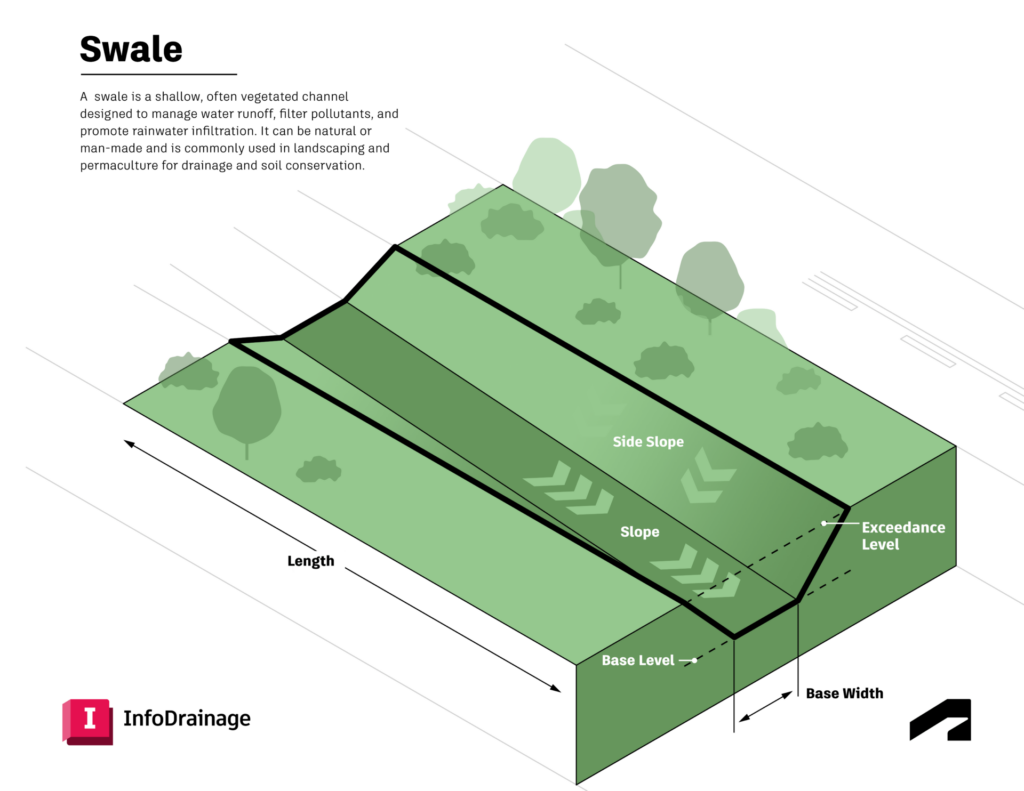
From a high-level view, swales are simply engineered ditches. They are typically shallow, gently sloping channels lined with vegetation, such as grasses or shrubs. They can range from small residential landscape features to large-scale, kilometer-long earthworks and are often designed to manage water runoff from impervious surfaces. Common applications of swales include residential landscaping (eg, to capture rain from a roof), parking lot edges, and along roadsides. They are sometimes used as pretreatment for another downstream stormwater tool, such as a rain garden or stormwater basin.
Designing a swale requires considering several factors, such as site contours, water flow patterns, and areas where water tends to pool. They are, in essence, engineered ditches. They are typically shallow, gently sloping channels that are v-shaped. But there is more to it than that. Swales have specific slopes – typically a gentle slope – to promote effective drainage and reduce erosion. Steep slopes may require additional stabilization or drainage measures to ensure land stability and proper water management.
Swales also have specific bottom widths and soil requirements; soil type influences their design, affecting the appropriate depth, slope, and ability to manage water flow and prevent erosion. In fact, these restrictions may be tightly controlled by local, regional, or national regulators, which means they must be carefully and thoughtfully designed. They are often designed to manage water runoff from impervious surfaces like roads, parking lots, and rooftops, but they can be placed anywhere.
The primary functions of swales are:
- Conveyance: Safely transporting stormwater from one location to another
- Infiltration: Allowing water to percolate into the soil, replenishing groundwater
- Filtration: Removing pollutants and sediments from stormwater through vegetation and soil
- Evapotranspiration: Releasing water back into the atmosphere through plant processes
Swales are a type of conveyance system that not only transport water but also provide water quality benefits by filtering and treating runoff through vegetation and soil.
Swales are often filled with vegetation, which helps slow down the velocity of the stormwater, and helps with infiltration of that water into the surrounding ground. Plants with deep root systems are typically selected for use in vegetated swales to improve soil stability. Grassed swales are typically lined with turf grass and are designed to control stormwater runoff velocity and infiltrate it where feasible.
But why use a swale over a more traditional ditch or culvert? Well, by working with nature, there are many benefits.
Benefits of swales for stormwater runoff
Swales offer numerous advantages over traditional drainage systems by helping to manage runoff in various settings. The four main benefits of swales are:
- Flood reduction: By slowing down and capturing stormwater, swales help reduce the risk of flooding in urban areas by reducing runoff volume and controlling excess water.
- Water quality improvement: Vegetation and soil in swales filter out suspended solids, sediment, and pollutants, including other pollutants such as nutrients and heavy metals, from stormwater. Swales improve water quality by filtering pollutants and other contaminants, enhancing the quality of water that eventually reaches natural water bodies.
- Groundwater recharge: Swales promote infiltration, which helps replenish groundwater supplies.
- Aesthetic and ecological value: Swales can be designed to enhance the visual appeal of urban landscapes and provide habitats for wildlife. They also help prevent erosion by stabilizing soil and slowing water movement.
- Community cost savings: Swales reduce the burden on municipal stormwater systems, potentially lowering community water management costs and reducing the risk of costly flood damage repairs.
Historically, many drainage designers have handled stormwater by building large culverts and making the surfaces that funnel water towards them impermeable by lining them with concrete. The idea is to forcibly move stormwater to where engineers want it to go, usually past an obstacle or into a subterranean waterway. But moving water away as fast as possible using impenetrable surfaces is not always the best solution.
By utilizing them and other sustainable urban drainage solutions, sites can not only handle changing stormwater events more effectively and efficiently than with culverts, but they can provide natural areas for vegetation and are naturally a habitat for surrounding birds, insects, etc. It’s an approach that not only seeks to use less concrete but to embrace natural ecosystems.
Different types of swales, including wet swales
Swales are often used alongside other features such as rain gardens for stormwater control and soakaways for infiltration drainage. They can be categorized into three main types: grassed, dry, and wet swales. Each type is tailored to manage water flow and runoff differently based on the environment and desired outcomes, demonstrating how swales work as conveyance systems for stormwater:
- Vegetated swales are shallow, vegetated channels designed to convey and treat stormwater runoff. Vegetated swales work by intercepting, slowing, filtering, and infiltrating runoff from paved areas, helping to control and slow water flow within the swale. They typically feature native grasses and vegetation, with plantings of native plants chosen for their suitability to the local climate, supporting local biodiversity and stabilizing soil. The planted vegetation and plantings are critical for water treatment and soil stabilization, while buffer zones can be used to further filter runoff and protect water quality. Sometimes, they’re simply called “grass swales”. Vegetated swales provide habitats for wildlife, including insects and pollinators.
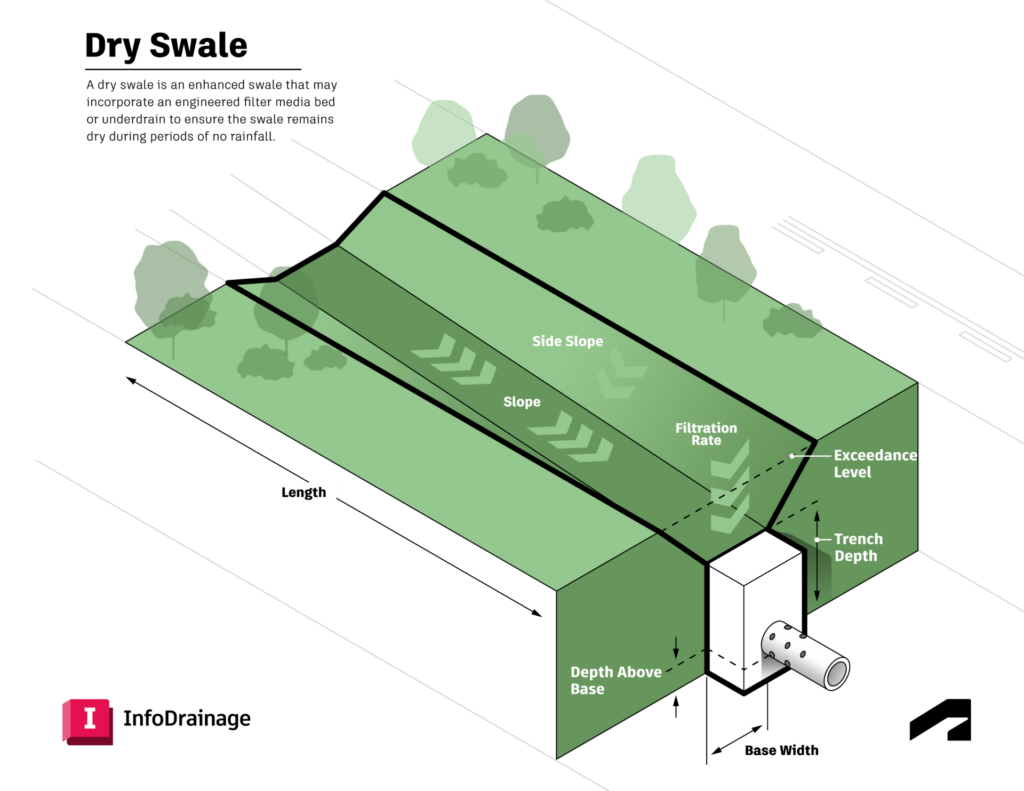
- Dry swales do not maintain a permanent pool of water, making them suitable for areas where prolonged saturation is not ideal. The key to their effectiveness lies in their design, which often includes underdrains to manage water levels during dry conditions. Check dams are often used within dry swales to slow water, promote sediment removal, and enhance stormwater infiltration.
- Wet swales are constructed to handle larger volumes of stormwater and maintain a permanent pool of water. These swales are maintained below the water table, allowing them to hold water and manage high water tables, which facilitates the growth of wetland plant species that aid in stormwater treatment. They have saturated soils and aquatic vegetation, unlike dry swales which prioritize infiltration. Buffer zones are also used in wet swales to further filter runoff and protect water quality.
They can also be used as pretreatment for downstream stormwater tools, such as rain gardens or stormwater basins, to further enhance stormwater management.
They slow down flowing water to reduce erosion and improve filtration, and can direct runoff to a storm drain or reduce reliance on storm drains as part of a broader stormwater management system. Managing grass clippings and other debris is important, as they can be carried by runoff and contribute to water pollution if not properly controlled.
What they call these systems around the world
Swales are simple in design, but guidelines differ slightly around the world:
- US: The Environmental Protection Agency (EPA) is generally considered the authority on how to implement swales across America. These systems are often referred to as LiD (Low-impact Development) strategies, but most construction and drainage professionals in the US use the term BMPs (Best Management Practices) – the preferred EPA term – to talk about the actual structures themselves.
- Australia: The acronym WSUDs (Water Sensitive Urban Design systems) is how they talk about sustainability down under. The Government of Western Australia’s Department of Water has a good PDF with construction details.
- UK: They call features like this SuDS (Sustainable Design Systems) in the UK, which makes them sound water-centric and natural. The UK government offers both regulations and grants to build swales, although details may differ in Scotland, Ireland, and Wales.
Modeling swales within InfoDrainage
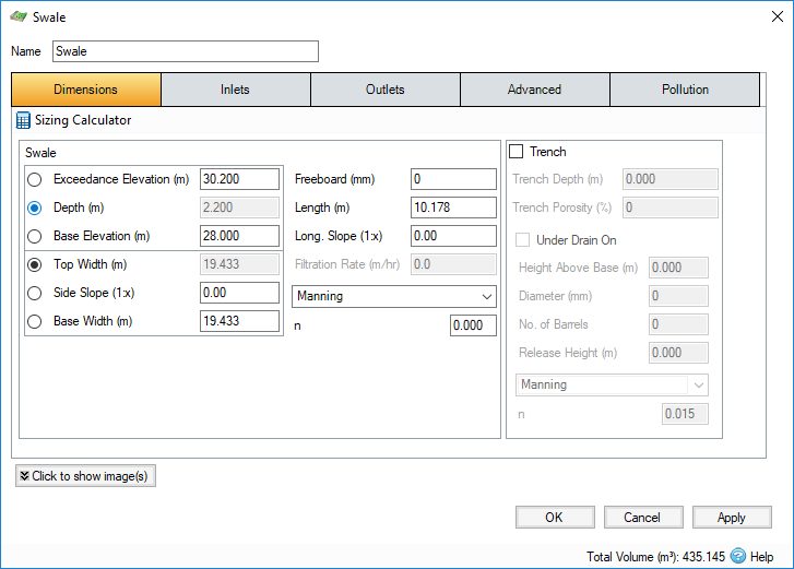
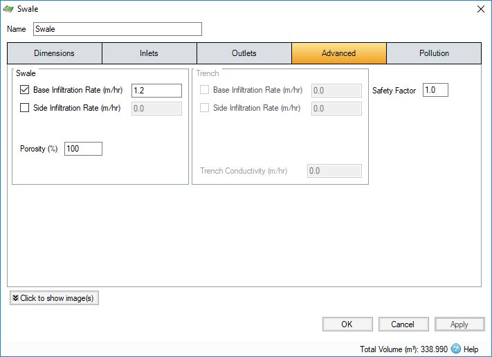
How might an engineer or hydraulic modeler know that the swale they designed can handle a flooding event? Engineers often use hydraulic modeling tools to understand how features like swales perform as part of a wider drainage network. Using apps like InfoDrainage, modelers can simulate stormwater events of any size and know the exact inflows and outflows.
InfoDrainage provides a suite of tools for modeling and simulating swales and other SuDS components, ensuring that they are optimally sized and positioned within the drainage network. It also allows for detailed hydrological analysis, helping engineers understand how they will perform under various storm events and conditions.
One of the benefits of using InfoDrainage is that you’re able to quickly generate compliant drainage reports for SuDS and LIDs by utilizing the built-in flexible reporting tool. This means that designing with more sustainable drainage systems and getting them through often antiquated approvals processes at your local authority can be easier than ever.
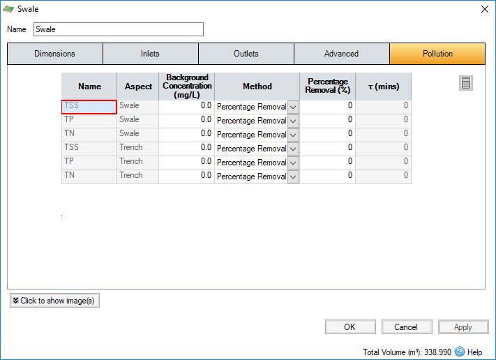
Designing with swales in InfoDrainage
Inside of InfoDrainage, you can model a range of stormwater controls including wet swales, vegetated swales, and dry swales. What makes the app powerful is that you can link all your SuDs together and see how the entire system works, giving you the opportunity to fine-tune the landscape of your project site.
For example, you may want to model them in conjunction with French drains, filter trenches, infiltration trenches, trench dry wells, wadis – all with or without under drain pipes. With InfoDrainage, you can very accurately model all these details and determine infiltration rates for not just each SuDs feature, but for the entire site.
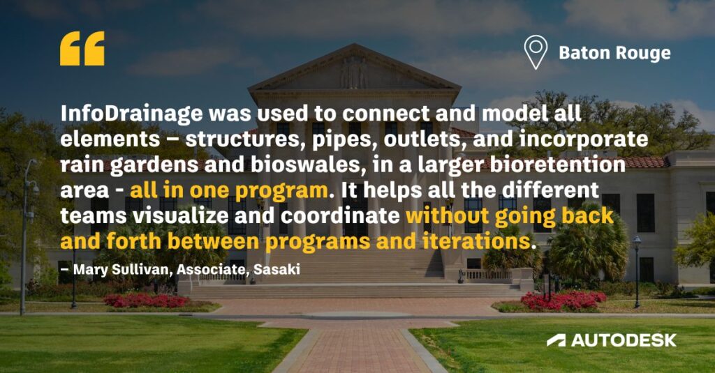
Why sustainability is important
What do you do when stormwater runoff overwhelms a lake, causing algae blooms, rotting vegetation, and suffocating fish? You carefully design a new nature-friendly drainage environment like Sasaki did for the University Lakes of Baton Rouge.
Maintenance and upkeep of swales
Proper maintenance is essential to keep them functioning at their best for stormwater management and water quality improvement. Over time, they can accumulate sediment, debris, and pollutants, which can reduce their ability to filter stormwater runoff and promote infiltration. Regular upkeep not only helps prevent soil erosion and sediment buildup but also ensures that they continue to remove pollutants effectively and protect local groundwater supplies.
Maintenance tasks for swales include litter and debris removal, grass cutting, and clearing inlets, culverts, and outlets from debris and sediment.
Conclusion and best practices for swale management
Swales are an essential part of sustainable stormwater management, providing a natural and cost-effective way to manage runoff and protect both communities and the environment. By promoting infiltration and slowing water flow, swales reduce the volume and speed of stormwater runoff, easing the pressure on municipal stormwater systems and helping to lower community water management costs. Their ability to filter stormwater through vegetated channels means that pollutants, sediments, and debris are captured before reaching local waterways, resulting in improved water quality and healthier ecosystems.
In urban areas, where impervious surfaces like parking lots, sidewalks, and rooftops increase the risk of flooding and water pollution, swales offer a practical solution. Vegetated channels designed with native plants like grasses, shrubs, and even small trees can help manage runoff, stabilize soil, and create habitats for wildlife. Features like check dams can be incorporated to further slow water flow, prevent erosion, and enhance infiltration, while also adding visual appeal to the landscape.
The Environmental Protection Agency (EPA) recognizes swales as a best management practice for stormwater control, highlighting their effectiveness in reducing stormwater runoff, improving water quality, and supporting environmental protection. By integrating swales into stormwater management systems, communities can not only reduce the risk of flooding and erosion but also contribute to a more sustainable and resilient future.
To ensure swales continue to deliver these benefits, it’s important to follow a set of best practices for their design, maintenance, and integration:
- Regular maintenance: Keep swales clear of debris, manage vegetation, and remove accumulated sediment to maintain their ability to filter stormwater and promote infiltration.
- Proper vegetation selection: Use native plants, including deep-rooted grasses and shrubs, to stabilize soil, filter pollutants, and support local wildlife.
- Thoughtful design: Consider soil type, slope, and expected water flow to ensure swales are effective at slowing and capturing runoff.
- Incorporate check dams: Use check dams or similar features to slow water flow, reduce erosion, and enhance infiltration, especially on steeper slopes.
- Monitor performance: Regularly evaluate swale function to ensure they are effectively managing runoff and maintaining water quality.
- Integrate with other systems: Combine swales with rain gardens, stormwater basins, and other green infrastructure for comprehensive stormwater management.
- Community education: Inform residents and stakeholders about the importance of swale maintenance and the role these systems play in reducing flooding and protecting water quality.
By adopting these best practices, communities can ensure their swales remain effective, resilient, and beneficial for years to come. Swales not only help manage stormwater runoff and reduce the risk of flooding, but they also enhance the visual appeal of urban landscapes, support biodiversity, and contribute to lower community water management costs. With careful planning, design, and ongoing care, swales are a powerful tool for building sustainable, water-smart cities.
Frequently asked questions about swales
What is a swale?
A swale is a shallow, vegetated channel designed to slow, store, and filter stormwater runoff. It helps reduce flooding and improves water quality by allowing water to infiltrate into the ground.
What is the purpose of a swale?
Swales are used to manage stormwater by reducing runoff speed, promoting infiltration, and removing pollutants. They are a key component of sustainable drainage systems (SuDS).
What is the difference between a swale and a ditch?
A swale is designed for stormwater management and typically includes vegetation to filter and slow water. A ditch is primarily used for drainage and may not include features to improve water quality or infiltration.
How does a swale work?
Swales slow down stormwater runoff, allowing sediments and pollutants to settle while water gradually infiltrates into the soil or is conveyed downstream in a controlled way.
Where are swales used?
Swales are commonly used in urban developments, roadsides, parks, and residential areas as part of sustainable drainage systems to manage surface water.
What are the benefits of swales?
Swales help reduce flooding, improve water quality, support biodiversity, and create more natural-looking drainage systems compared to traditional pipes.
Go deeper into sustainable design
In addition to this article on swales – as part of our sustainable drainage guide, we have articles on infiltration trenches, cellular storage, porous pavement, soakaways, bioretention systems, rain gardens, and wet ponds and infiltration basins – plus plenty of other resources about stormwater controls:
- We have a Guide to Representing SuDS in InfoDrainage in accordance with the SuDS Manual Ciria 753.
- Our documentation shows you how to input specific constraints to accurately model and size your swale.
- Prefer a video walkthrough? Check out our free course Designing a swale.
- Don’t have a copy of InfoDrainage? We offer a 30-day free trial with no credit card required.
- Are you a student or educator? If so, we have some very good news for you.