 Louise Cramp
Subgrid sampling (SGS) is an approach to 2D hydraulic modelling that allows more detail from the underlying ground model, often represented by a Digital Elevation Model (DEM) or Digital Terrain Model (DTM), to be retained within the computational mesh.
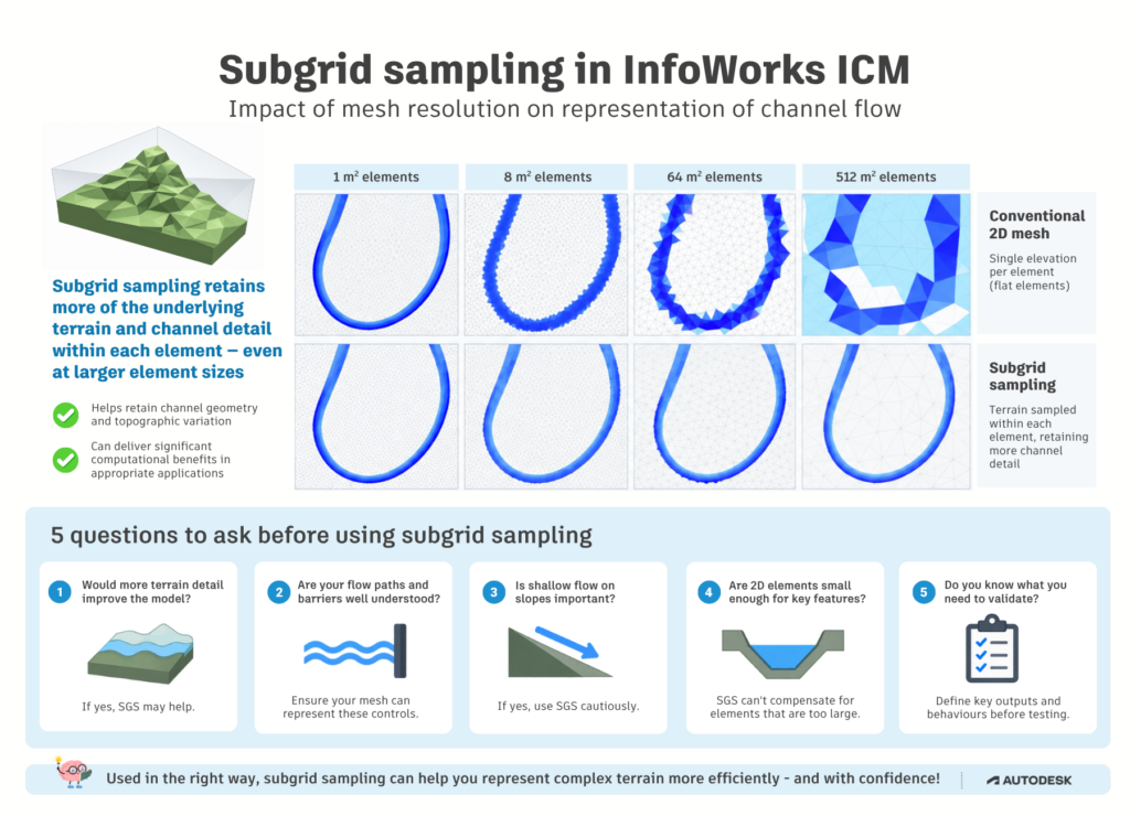
Subgrid sampling isn’t simply a faster alternative to a conventional 2D mesh.
A useful way to think about SGS is that a conventional element uses a simplified, averaged representation of the ground surface, while SGS retains much more of the terrain variation within that same computational element.
Using larger computational mesh elements while retaining much more of the detail from the underlying ground model can significantly improve simulation performance in the right applications.
📚 If you’re new to working with computational meshes, our guide to 1D vs 2D hydraulic modelling explains how 2D meshes represent flow across a floodplain.
Whether you should use subgrid sampling depends on the problem you’re trying to solve, the hydraulic behaviour you need to represent and the features that control how water moves through your model.
Below are five questions to consider before using SGS. If you can answer these five questions, you will be in a much stronger position to decide not just how to use subgrid sampling, but when it is the right modelling choice.
1. Would representing more of the detail in my ground model improve the model?
To understand when subgrid sampling might be useful, it helps to separate two parts of a 2D model: the computational mesh and the ground model.
The computational mesh divides the 2D domain into elements across which the hydraulic calculations are performed. The ground model, or DTM, describes the shape and elevation of the terrain within that domain.
In a conventional 2D model, variation in the ground surface is simplified when it is represented within each computational element. This means each element uses a much simpler representation of the ground than the full detail available in the DTM.
Subgrid sampling allows InfoWorks ICM to sample the ground model at a finer resolution within each computational element, so that more information about the shape of the terrain and the storage available within the element can be retained.
Conceptually, SGS is not a different way of meshing the model. The mesh defines the computational elements and how they connect. SGS determines how much of the underlying DTM detail is represented within those elements. (For more on the underlying calculations, see InfoWorks ICM’s Subgrid Sampling methodology.)
For example, imagine that one 2D element covers an area containing several small variations in ground level. With a conventional representation, much of that variation is simplified. With SGS, the underlying DTM is sampled at a finer resolution so that those variations can contribute to how water is stored within the element.
In InfoWorks ICM, SGS settings are applied as part of the mesh-generation workflow, so turning SGS on can also affect meshing behaviour. This can make SGS and meshing feel like the same decision. It is useful, however, to keep the concepts separate: the modelling purpose of SGS is to make greater use of the terrain information available within the elements of the mesh.
Key question: Is useful terrain detail being lost when the ground surface is simplified within my 2D elements?
If yes, SGS is worth considering.
Capturing more terrain detail inside an element does not, however, solve every hydraulic representation problem. Features that control whether water can move from one element to another still need additional consideration. We’ll look at those next.
2. Are the important flow paths and hydraulic barriers clearly understood?
Subgrid sampling can represent considerably more topographic variation inside a computational element. But flow is still exchanged across computational element boundaries.
That distinction is particularly important for features such as:
- embankments
- flood defence crests
- walls
- roads acting as barriers or conveyance routes
- narrow channels
If an important crest passes through the middle of a large subgrid element rather than following its boundary, simulated flow may pass through that feature. Use breaklines along significant topographic crests so that element faces align with the hydraulic barrier.
A useful principle: Use the subgrid to describe the terrain within an element. Use the computational mesh and breaklines to represent the hydraulic controls between elements.
When those important flow paths and barriers are well understood, SGS can be a strong modelling option because you can be deliberate about where computational boundaries are required instead of refining the entire mesh indiscriminately.
3. Is shallow flow moving freely down significant slopes an important part of the model?
This is one of the situations where you should be more cautious when using subgrid sampling.
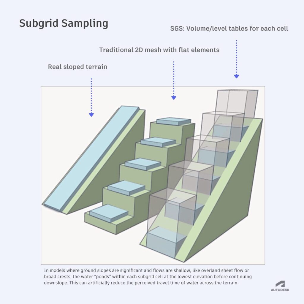
SGS uses the terrain information within each element to describe storage. Under some conditions, particularly with shallow water moving freely downhill, this representation can result in over-rapid propagation speeds. This is especially relevant when modelling rainfall applied directly to the mesh in hilly areas.
This is an important limitation of subgrid sampling to consider when modelling shallow overland flow on significant slopes. This means that if the timing and movement of shallow overland flow across slopes are central to the question you’re trying to answer, SGS across the entire 2D domain may not be the best starting point.
But the choice doesn’t have to be SGS everywhere vs SGS nowhere.
InfoWorks ICM allows SGS properties to be applied through Mesh zones. In situations where shallow downhill propagation is a concern, you may want to consider SGS in selected areas such as low-lying regions, areas of interest or locations where flow paths are clearly defined, rather than applying it to the whole 2D zone.
Key question: Where in my model does SGS give me an advantage, and where would conventional 2D behaviour be more appropriate?
Selective use of SGS might be the best option.
4. Are my 2D elements small enough to represent the hydraulic features that matter?
SGS allows more detail from the ground model to be represented within each 2D element. But the size of the computational elements still matters.
Using subgrid sampling does not mean that 2D element size no longer matters. If an element is very large compared with an important hydraulic feature, capturing more terrain detail inside that element does not necessarily mean the model will represent the movement of water around that feature correctly.
A river channel is a useful example. SGS may retain detailed river-bed elevations within an element, but if the element itself is large relative to the width of the river, flow between neighbouring elements can misrepresent how water moves along the channel or between the river and floodplain.
Current InfoWorks ICM guidance therefore recommends using a 2D element size smaller than the river bed when applying SGS to river modelling.
The same principle is worth considering anywhere your model contains relatively narrow features that have an important influence on flow.
These might include:
- narrow river or drainage channels
- constricted flow paths
- narrow road corridors that convey flow
- other small-scale features that materially influence how water moves through the model
Key question: Are my planned 2D elements small enough relative to the hydraulic features that I need the model to represent?
If not, review whether the computational element size is appropriate before relying on SGS in that area.
SGS can give you a more detailed representation of the terrain within an element, but it cannot compensate for an element that is too large to represent an important hydraulic feature appropriately.
5. Do I know what I need to validate if I move to SGS?
Before implementing SGS, think about how you will validate your model outputs.
Validating a subgrid sampling model means checking not only performance, but whether it reproduces the hydraulic behaviour and level of accuracy your project requires.
Start by identifying the hydraulic behaviours and model outputs that matter most to the decisions your model is supporting.
These might include:
- flood extent
- maximum water depth
- velocity
- flow paths
- water levels at important locations
- arrival time and flood timing
- flows across key sections
- overall model behaviour and stability
- simulation time and computational requirements
You may already have a trusted conventional 2D model that can provide a useful reference. If so, decide in advance which outputs you will compare once you create an SGS version.
If you’re building a new model, think about other evidence you can use to assess its behaviour, such as observed data, known flood mechanisms, flood studies or engineering expectations.
Once you’ve implemented SGS, you can then assess whether it reproduces the hydraulic behaviour and level of accuracy you need for the decisions the model is intended to support.
If important behaviour changes in ways that matter to your project, revisit the computational element size, breaklines, SGS resolution or where SGS is being applied.
Validation therefore isn’t just a final check. Planning how you will validate the model is part of deciding whether SGS is the right approach in the first place.
So, when should you use subgrid sampling?
There isn’t a universal answer, and that’s the point.
Subgrid sampling gives InfoWorks ICM modelers another way to represent detailed terrain without automatically requiring an equally detailed computational mesh. In appropriate applications, that can deliver significant performance benefits.
But the decision shouldn’t begin with:
“How much faster can I make my model?”
Start instead with:
“What hydraulic behaviour does my model need to represent?”
Subgrid sampling may be a good fit when your ground model contains important detail that would otherwise be simplified within your 2D elements, your important flow paths and barriers are well understood, and the planned mesh can represent the hydraulic controls that matter.
If shallow flow down slopes is critical, or important channels and barriers would not be represented appropriately by the planned mesh, use subgrid sampling more selectively or consider retaining a conventional 2D approach in those areas.
Put subgrid sampling into practice
Learn how to use subgrid sampling in InfoWorks ICM, or explore InfoWorks ICM for integrated 1D and 2D hydraulic modelling.