Integrated catchment modeling is the simulation of how water moves across an entire catchment by combining rivers, drainage networks, and surface flow within a single model. It allows engineers to understand how different parts of a water system interact during events such as flooding by performing complex hydraulic modeling. This approach combines 1D and 2D modeling to represent both network flows and surface behavior in a single system.
Flooding rarely comes from just one place:
- A drainage network may surcharge and flood a road.
- A river may overtop its banks and spill into the floodplain.
- Surface water may race downhill, find the lowest point, and enter a system where it was never supposed to go.
And sometimes the same location is affected by all three – at different times and for different reasons. That’s exactly when integrated catchment modeling matters most.
What is integrated catchment modeling?
Integrated catchment modeling is the process of simulating how water moves across an entire catchment, which is used to represent how water flows through systems such as rivers, drainage networks, and surface environments.
Instead of analyzing systems in isolation, it brings together:
- Underground sewer and drainage networks
- Rivers and open channels
- Surface runoff and overland flow
- Floodplain storage and interactions
This allows engineers to understand how water behaves across a whole system, rather than just one part of it.
Why separate models are not enough
Traditionally, different parts of the water system were modeled separately:
- Sewer models focused on pipes and manholes
- River models focused on channels and floodplains
- Surface models focused on overland flow
Each answered part of the problem, but not the whole picture. That gap matters.
For example, a drainage system may flood a street early in a storm due to capacity limits. Later, rising river levels may force water back through the same network. What looks like one flooding issue may actually be multiple interacting processes. Without integration, it’s easy to miss how these systems influence each other.
In practice – now that engineers use more advanced software – many projects now take a system-wide approach. For example, cities have developed holistic watershed models that combine river and drainage systems to better understand flood risk across entire catchments.
How integrated catchment modeling works
Integrated catchment modeling typically combines 1D and 2D hydraulic modelling approaches, allowing engineers to represent both network flows and surface behavior within the same system:
- 1D modeling for pipes and river channels
- 2D modeling for surface flow and floodplains
- Hydrological inputs such as rainfall and runoff
This allows engineers to simulate interactions such as:
- Sewer surcharge causing surface flooding
- River overtopping affecting urban drainage
- Surface water entering and re-entering networks
- Compound flooding events
Why this matters in the real world
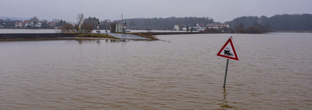
Consider an urban catchment connected to a river.
At the start of a storm, local flooding may occur because the drainage network cannot carry incoming runoff. Later, as the river rises, it may overtop and push water back toward the urban area.
At that point, the system can start working in reverse.
Instead of water leaving the network, river water enters it, forcing flows back through pipes and onto the surface elsewhere.
In practice, this type of interaction is often analyzed using integrated models that combine sewer networks and surface flow, as demonstrated in projects such as integrated 1D and 2D modelling in urban environments. These same approaches are also used in the design of systems such as sustainable drainage systems (SuDS), where runoff is managed across a site rather than conveyed directly into pipes.
That is not just a river problem – or a sewer problem. It is a catchment problem.
One location, different flood mechanisms
In some catchments, the same location can flood in completely different ways:
- Short, intense storms may cause local drainage surcharge and street flooding
- Longer events may raise river levels and trigger floodplain inundation
The result looks the same, but the causes are different.
Understanding those differences is essential for:
- Identifying the true source of risk
- Designing effective interventions
- Avoiding solutions that shift problems elsewhere
These differences are driven by how rainfall becomes runoff and moves through a catchment, highlighting the importance of understanding both hydrology and hydraulics together.
Above ground and below ground—together
Water does not recognize system boundaries. It moves between:
- Pipes
- Rivers
- Streets
- Floodplains
Sometimes all within the same event.
Integrated modeling helps engineers track those pathways and understand:
- Where flooding begins
- How it spreads
- When it changes source
- How different systems interact
These differences are driven by how rainfall becomes runoff and moves through a catchment, highlighting the importance of understanding both hydrology and hydraulics together.
As climate change increases the frequency and intensity of extreme rainfall, the need for system-wide modelling is becoming more urgent. Many organizations are already applying advanced hydraulic modeling to respond to rising flood risk.
The value of one modeling environment
Integrated catchment modeling allows engineers to work in a single environment rather than stitching together multiple models.
This improves:
- Consistency
- Confidence in results
- Workflow efficiency
- Communication with stakeholders
It also enables more advanced workflows. Engineers can now test multiple scenarios and improve system performance using scenario-based hydraulic model optimisation techniques.
Looking at the whole catchment
Integrated catchment modelling is about seeing the whole system. Not just the sewer. Not just the river. Not just the surface. But how all of them interact – before, during, and after a storm event.
Because in the real world, flooding rarely has a single cause. It emerges from the way systems connect, overlap, and respond under pressure.
What InfoWorks ICM enables
InfoWorks ICM was developed to support integrated catchment modeling by combining:
- 1D sewer and river modeling
- 2D surface and floodplain modeling
- Interaction between natural and engineered systems
This allows engineers to simulate how water moves across a catchment during both everyday conditions and extreme events.
Explore how this fits into the broader ecosystem in Autodesk’s water infrastructure modeling approach.