With heavy short-term rainfall events becoming more intense, it’s critical that Australia’s flood maps are dynamically altered to include the most up-to-date ARR guidelines. Because our software offers customizable rainfall calculations, you can adjust equations to go beyond standard calculations – to account for climate change or to apply specific details that affect your location.
Australia is dealing with a one-in-100-year flood far more frequently than once every century. Evidence shows Australia has warmed by 1.5°C since national records began in 1910. And hotter the atmosphere, the more moisture it can hold. The result? More rain.
The good news is that, as water professionals, we can adapt the way we work to meet these challenges. Now is the time for flood modellers – and not just those in Australia – to adjust their models to take into account the coming deluges.
In fact, you can do this right now by customizing the rainfall and runoff calculations in the software you use, whether that is InfoWorks ICM, InfoDrainage, or other software you rely on for flood or drainage modelling. Everything is customizable, so you can adjust your calculations to fit a region, to fit a project, or just to test out a theory.
How to customise ARR in our software to take into account the latest update
If you want to dive right into updating ARR calculations before reading about the details around the latest changes, we have two short videos that can walk you through the process in a simple and straightforward way. 👇
Australia is sounding the climate alarm
Since the start of 2025, Australia has seen 19 flood- or storm-related incidents. Flooding is becoming a regular occurrence in many parts of the country, with homes, businesses, and farmlands often getting overwhelmed by fast-moving, heavy waters.
According to the According to the CSIRO and Bureau of Meteorology’s biennial report on the State of the Climate, short bursts of heavy rain are getting more intense. What used to be considered a worst-case scenario, like a 20% increase in annual rainfall by the end of the century, is now seen as the best-case scenario. So, the real question now isn’t if severe floods will happen, but how ready we are to deal with them.
But, it’s not simply about more rain happening everywhere. Effects will be different in different parts of Australia – unevenly distributed. As CSIRO notes, in northern Australia, average wet-season rainfall is now about 20% higher than 30 years ago. But in southwestern Australia, rainfall in the cooler, growing-season months has declined 16%, and in the southeast by 9% in recent decades.
Like with any disaster, the first step is understanding the risk. For floods, this means flood mapping – maps that show which areas are more likely to flood and where water tends to collect during big storms. These maps are essential for understanding flood risks and planning how to respond and reduce damage. The problem is, most flood maps are outdated and don’t take climate change into account properly, which puts people and property at risk.
The devastating floods in New South Wales and Queensland in 2022 showed just how urgent it is to update these guidelines to reflect the reality of climate change. And that’s what has happened with ARR, partly in response to these particularly devastating floods.
Why the Australian Rainfall and Runoff guidelines are so important
Australian Rainfall and Runoff (ARR) is the cornerstone reference for flood estimation, water management, and infrastructure planning across Australia. Developed and maintained with the support of the Australian Government and Geoscience Australia, the ARR guidelines provide authoritative, practical flood guidance and runoff guidelines that underpin the safety and sustainability of communities, infrastructure, and the environment nationwide. ARR has undergone various updates since its first publication in 1958 to reflect current best practices.
The ARR 2019 is widely recognized and used by engineers, planners, asset owners, and government agencies to assess flood risk, inform design flood estimation, and guide the development of resilient infrastructure. Its application is essential for ensuring that new developments avoid high flood-risk areas and that existing assets are managed with the latest understanding of Australian rainfall and runoff processes.
But the Australian guidelines are especially important because – if current trends continue – Australia will be one of the nations hit hardest by climate change. So it is heartening to see that the water industry and the people who help propel it forward have already elevated the importance of revising rainfall and runoff guidelines with the release of Version 4.2’s improved guidance on how to consider climate change when planning for future floods.
Who changed ARR – and what did they change?
The update was initiated by the Australian Government’s Department of Climate Change, Energy, the Environment and Water in partnership with Engineers Australia and was funded through the National Emergency Management Agency’s Disaster Risk Reduction Package. The big change? They’ve revised the “Climate Change Considerations” chapter (Book 1, Chapter 6) with updated guidance that aligns with the latest international research findings, climate projections, and best practices for flood estimation and management.
Who is they? Kudos for this chapter update goes to a long list of contributors who deserve credit for steering their committees to fruitful and workable conclusions. They all worked together on an extensive 18-month project that included a comprehensive literature review on hydroclimatology, climate change considerations, and design flood estimation, incorporating the latest peer-reviewed climate change science, IPCC projections and observed data. The changes also reflect a lot of valuable feedback from extensive industry consultation to not just address theoretical concerns but real-life best practices.
Their framework and methodology
At the beginning of the chapter, the working group lays down a strong recognition of climate change based on “unequivocal evidence that greenhouse gas emissions have caused global warming”, with the conclusion that historical observations are no longer representative of current and future conditions. Therefore, they conclude, as water professionals we must adjust our calculations – and indeed will probably need to keep adjusting them over time.
They then lay down a basic methodology that water professionals can use to choose their approach to design flood estimation in the context of two sources of uncertainty:
- Aleatory uncertainty, which comes from an inherent randomness and variability in all natural systems
- Epistemic uncertainty, which comes from a lack of knowledge or incomplete information about a system or process.
In essence, the message here is that climate change is shifting our best estimate of the relationship between event magnitude and frequency and increasing the inherent uncertainty in our estimates.
These differences are manifested in different ways when it comes to flood modeling. Aleatory uncertainty is about variability in rainfall patterns, flow rates, or natural flood events that cannot be predicted precisely. Even with perfect knowledge of the system, the randomness in these natural phenomena would still lead to some uncertainty in flood predictions. In contrast, epistemic uncertainties come from the parameters of flood models, or gaps in knowledge about the topography and land use that affect flood behavior. By enhancing data accuracy, improving model formulations, or obtaining better measurements, this second type of uncertainty can be reduced.
Key details from the revised Chapter 6
With that framework defined, they get to the meat of the changes:
- The guidelines promote the use of advanced digital and computational tools for more accurate flood risk assessments.
- They encourage modellers to move from uniform to variable rainfall adjustments. This reflects evidence that the duration of a storm matters for estimating how temperature affects rainfall, with shorter duration storms being significantly more affected.
- A recommendation to adjust 2016 Intensity-Frequency-Duration (IFD) curves to current climate conditions from Version 4.1 from 2019.
- They conclude with specific examples to demonstrate how to apply the updated guidance.
Revising flood maps to account for the ARR update
There is widespread acknowledgement across Australia that many flood maps are very outdated and that this is a big problem. The problem is not simply one of intent, but of capacity. Updating flood models to reflect current conditions, let alone the projected impacts of climate change, has traditionally required significant time, resources, and computational effort.
This is where advances in technology are beginning to transform what was once a monumental task into an achievable, scalable process. With the advent of cloud computing, tools like InfoWorks ICM enable engineers to build, calibrate, and run highly detailed hydrologic and hydraulic models much, much faster and more efficiently than ever before. What used to take days of computation can now be completed in hours or even minutes by running them parallel across the cloud. For councils and utilities under pressure to respond to community concerns about flood resilience, this acceleration can be a real game-changer.

Ultimately, modernising flood management in Australia requires a combination of updated science, forward-thinking policy, and the right technology. By embracing cloud-powered simulations and aligning with ARR’s climate change guidance, the industry has an opportunity to overcome the long-standing issue of outdated resources and deliver more resilient outcomes for communities.
The reality is, the terrain and weather patterns we are trying to map are changing so rapidly that traditional modes of collecting and collating flood-related data can no longer keep up. For example, CSIRO’s guidance on rainfall intensity in Australia varies drastically depending on future emissions, saying the intensity of daily rainfall with a one-in-20 year average recurrence may increase 4-10 per cent by 2050 for a low-emission scenario and 8-20 per cent by 2050 for a high-emission scenario. To account for the uncertainty and risk, we’ll need to model multiple scenarios and keep adjusting our models.
As a flood modeler, you may need to go even deeper to reflect the changing climate and rely on live models that can be adjusted quickly and efficiently. You will also presumably need to create larger and larger models to capture true-and-accurate catchment-wide effects. All of this will require more computing power, which only the cloud may be able to provide.
An example from neighboring Tasmania
Those larger models already exist and can serve as an example for Australians – for example, in neighboring Tasmania.
After major floods swept through parts of Tasmania in 2016 and 2018, the Tasmanian government and the federal government invested in a comprehensive flood-mapping project to better understand the statewide flood risk and in doing so built resilience and support for future emergency response situations and recovery decision-making. Flood maps were updated using a strategic modelling environment based on RAFTS + InfoWorks ICM which used hydraulic and hydrodynamic models and collated a large volume of data on historic flood events to create a more accurate map.
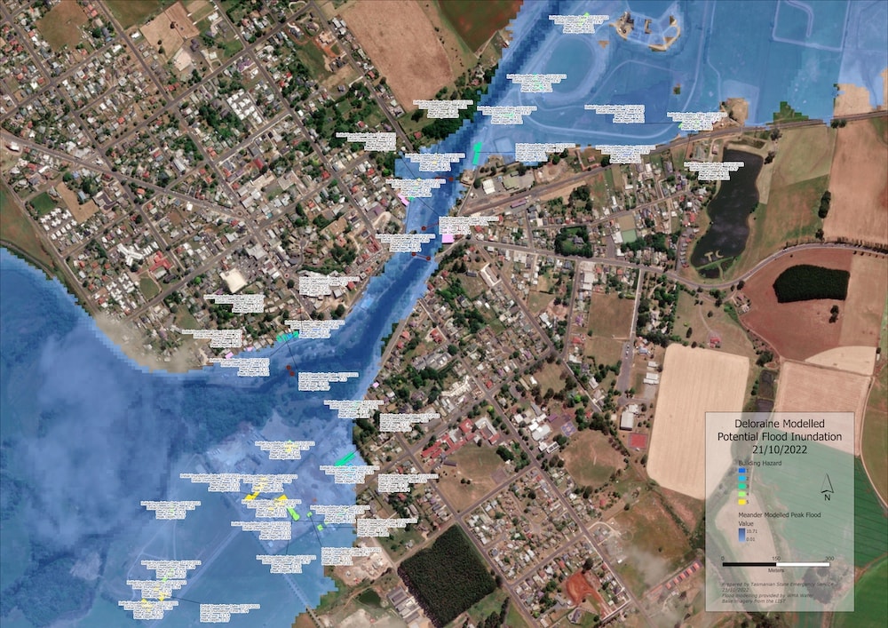
In 2022, this was put to the test as record flooding headed towards the state. As the weather pattern moved through Tasmania, the model was used to forecast rainfall data and deliver predictive impact maps 12 hours before the rain started to fall. This greatly assisted operational response strategies, as well as public information warnings.
A final word about navigating difficult political waters
Obviously, the most important reason to update flood maps is to protect more lives and safeguard communities, and that was the big focus of the Tasmanian flood models. But there are other factors in the Australian flood equation – big financial factors. Recent research suggests that floods have caused a drop of $42.2B in the value of Australian homes.
When flood maps get updated, developers change direction, cancelling projects in some locations and investing in new ones elsewhere. Insurance companies adjust rates, and, of course, flood maps are a major factor in determining homeowners’ insurance rates. Residents who have lived in one place their entire lives may wake up to find that their property now exists in a flood zone. These are some of the unexpected and unfortunate effects of climate change that governments and regulating bodies will have to increasingly grapple with – that they indeed are already struggling with.
Many of the arguments and considerations that come out of these struggles will hinge on finely-grained details of flood maps. Therefore, these flood maps will need to be as scientifically accurate as possible – and as defendable as possible. They will need to rely on the most accurate data available. They will also need to be easily and efficiently updated to take into account alternate scenarios.
For example, if you are commissioned to create a comprehensive flood map, it may not be easy to convince everyone involved that the original flood map you created is the best flood map to follow. Politicians, developers, citizens, utilities, governing bodies, academics – the many constituencies who will need to find compromises together – may ask you for additional flood maps to take into account multiple proposals, in an attempt to find common ground between competing interests. All of this can be made much easier by relying on high-tech tools that offer speedy, cloud-driven simulations.
In other words: We do not just need our flood maps to be as accurate as possible. We need to be able to present a plethora of options to our clients – and to society as a whole – so we can together, collectively make difficult decisions. As flood modellers, we will need to make many fine-grained adjustments to help Australians make large-scale changes and be adaptable and resilient to a changing climate.
Get acquainted with the new ARR guidelines
- Available in multiple formats, including PDF and EPUB, the ARR guidelines are freely accessible and can be downloaded from the official ARR website. Read the official guidelines in the complete ARR Guidebook (Version 4.2) or jump directly to Book 1 and read Chapter 6 for the most up-to-date guidelines.
- Do you want to follow Australia’s example and advocate for changing rainfall and runoff calculations in your region or jurisdiction? Check out Dr. Conrad Wasko’s excellent presentation document that summarizes their goals and their process for changing rainfall and runoff guidelines, which is published by the Australian Water School.
- Do you use InfoDrainage? We have a video that shows you How to use Australian Rainfall and Runoff (ARR19) guidelines in InfoDrainage