Stormwater, wastewater, and flood modelling
Build stronger community resilience and improve environmental protection against the pressures of urbanization and extreme
weather events.
Build stronger community resilience and improve environmental protection against the pressures of urbanization and extreme
weather events.
Better serve the needs of your community by forecasting how your system will respond to varying conditions. Model complex wastewater and stormwater network elements to inform decisions around capacity fluctuations, system expansions and emergency scenarios.
Image: InfoWorks ICM shows wastewater network where red circles represent an alert for a potential pump station failure.
Advanced technology for hydraulic and hydrologic modelling allows you to quickly build trusted models that inspire confident decision making.
Model multiple scenarios to evaluate where system stresses could emerge during extreme weather events.
A single platform for projects creates a trusted space for all stakeholders to collaboratively work with up-to-date and accurate models.
1D and 2D modelling in one package gives you a complete view of the interactions between your above ground and underground network.
Powerful hydraulic simulation with multiple engines provides fast and reliable results to support complex decision making.
Stormwater and wastewater professionals are key drivers in creating actionable plans for reducing the impact of flood risk, spills, pollution, and asset failures. In this e-book, learn how advances in technology have allowed us to adapt and adjust our surroundings to ensure that the impacts of urbanisation and extreme weather do not put our environment or communities at risk.
Arcadis
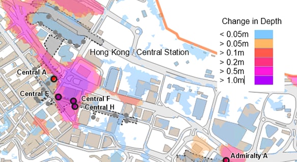
High-level screening models and thematic mapping styles help to visually represent flooding risks and impacts of climate change across a large area of Hong Kong.
Image courtesy of Arcadis
Atkins
A catchment model of river, surface water and foul water components was used to understand the existing flood risk mechanisms and drive better decision-making in Surrey County.
Dekalb County
The use of a Groundwater Infiltration Model (GIM) allows Dekalb County to dynamically account for increases in groundwater during the wetter months.
Integrated catchment modelling software enables you to model complex hydraulic and hydrologic network elements quickly, accurately, and collaboratively so you can improve your stormwater and wastewater planning and management.
As a global leader in the integration of architecture, engineering, construction, product design, and manufacturing processes, Autodesk can help you develop the capabilities needed to achieve your goals.
Reach out today to schedule your business consultation.
Wastewater and stormwater engineers, planners, project managers and consultants use InfoWorks ICM to face evolving challenges driven by regulations, level of service, customers, environment and operations. By building accurate and holistic models, we’re able to forecast how a system will respond to varying conditions. This allows you to better respond, plan, and fulfil the needs of your community. Plus, you can do it all using an industry-trusted, cross-team solution.
Stormwater management is the effort to reduce rainwater runoff over roads, buildings and other surfaces to reduce debris or pollutants that it may collect and trickle into rivers, lakes or streams. Rainwater in a natural environment soaks into the ground, however, urban development contains a number of impervious surfaces that will misdirect rainwater to rush into storm drains, wastewater systems, and drainage ditches, causing flooding, erosion, turbidity (or muddiness), overflowing storm and sanitary sewer systems, and infrastructure damage.
Digital models give wastewater system managers a baseline to understand and simulate the performance of their network. If a sewer district needs capacity improvements, a wastewater model will help plan exactly where additional capacity is needed based on geographical characteristics and load allocations for both dry and wet weather conditions.
Additionally, a model can help locate sources of inflow and infiltration (I/I) as well as blockages, so that combined sewer overflows (CSOs) and sanitary sewer overflows (SSOs) are less likely to occur.
Organisations dealing with stormwater, flooding, and sewers face a complex mix of requirements, including the need to:


