Water doesn’t stay in one place.
It flows through pipes, along rivers, across streets, and sometimes into places it shouldn’t be – like homes, roads, and critical infrastructure. Understanding where that water will go, how fast it will move, and what happens when systems are pushed beyond their limits is at the heart of hydraulic modeling.
At its simplest, hydraulic modeling is the simulation of how water moves through natural and engineered systems. But in practice, it’s much more than that. It’s how engineers predict flooding, design infrastructure, manage risk, and plan for an uncertain future.
This guide explains the fundamentals of hydraulic modeling, how it works, and how modern approaches allow engineers to model entire catchments –not just individual systems.
What is hydraulic modeling?
Hydraulic modeling is the process of simulating how water flows through systems such as:
- Pipes and manholes
- Rivers and open channels
- Culverts and bridges
- Surface floodplains
- Entire catchments
It uses mathematical equations to represent the movement of water, allowing engineers to calculate:
- Flow rates
- Water levels
- Velocities
- Flood extents
It’s important to distinguish hydraulic modeling from hydrology.
- Hydrology focuses on how rainfall becomes runoff
- Hydraulics focuses on how that water moves through systems
At its core, hydraulic modeling applies principles such as:
- Conservation of mass (continuity equation)
- Energy balance
- Resistance equations like Manning’s equation
Why hydraulic modeling matters
Hydraulic modeling supports decisions that directly affect people and infrastructure:
- Flood resilience
- Sewer capacity
- Infrastructure design
- Regulatory compliance
- Climate adaptation
- Operational performance
For example, hydraulic models are used to test how SuDS features perform under different rainfall scenarios, ensuring they meet flood risk and regulatory requirements.
All of this is done to answer – in very specific detail –what happens when it rains—and what happens when systems fail?
The different types of hydraulic modeling
Flood risk assessment
Understanding where water flows during extreme events. In practice, flood modelling often operates at a city or catchment scale. For instance, cities like San Marcos in Texas use hydraulic models to map flood risk across entire urban areas. On a smaller scale – in the heart of cities – hydraulic modelling is often used to design Sustainable Drainage Systems (SuDS), helping engineers manage runoff close to its source and reduce pressure on drainage networks.
Sewer and drainage capacity
Identifying bottlenecks, surcharge risks, and overflow conditions. In urban drainage systems, hydraulic modelling is often used to identify bottlenecks, surcharge risks, and overflow conditions. For example, engineers in Toronto use modeling to understand how sewer capacity limitations were contributing to flooding during storm events.
River and floodplain modeling
Assessing overtopping, storage, and flow behaviour. For example, in projects like ISG’s FEMA-approved flood modeling work, engineers moved from traditional river cross-section models to more detailed 1D and 2D simulations to better represent floodplain behaviour and improve accuracy.
Climate resilience
Testing future rainfall and environmental conditions, for example when you need to very accurately test stormwater conditions in a city. In many cities, the need for hydraulic modelling isn’t theoretical, it’s driven by real events. In Fayetteville, North Carolina, repeated major storms exposed the limits of traditional, small-scale drainage improvements. Instead of continuing to respond project by project, the city used hydraulic modeling to understand flooding across its entire watershed and plan long-term, resilient solutions.
Operational optimization
Supporting real-time system decisions. By combining models with SCADA data and weather forecasts, utilities can monitor system performance, predict issues, and respond proactively. For example, flood early warning systems and operational models allow teams to anticipate risk and act before flooding or overflow events occur.
1D vs 2D hydraulic modeling
1D hydraulic modeling
It is typically used for:
- Sewer networks
- River channels
Advantages:
- Fast and efficient
- Suitable for large systems
2D hydraulic modeling
It is typically used for:
- Floodplains
- Surface flooding
Advantages:
- Realistic flow representation
- Detailed flood mapping
💡 Which one should you use – 1D, 2D, or an integrated approach? We have an article to help you decide.
Integrated catchment modeling: where systems meet
In reality, water doesn’t stay in one system. It moves between pipes, rivers, and the surface, often within the same storm event.
A drainage network may surcharge and flood a road. Later, rising river levels may force water back through the same system. Surface runoff may enter a network and reappear elsewhere.
This is where integrated catchment modeling becomes essential.
Rather than modeling each system separately, integrated models bring together:
- 1D pipes and channels
- 2D surface flow
- Hydrological inputs
This allows engineers to simulate interactions such as:
- Sewer surcharge causing surface flooding
- River overtopping affecting urban drainage
- Compound flooding from multiple sources
For example, an integrated model allows engineers to simulate how SuDS features interact with sewer networks, rivers, and surface flow across a catchment.
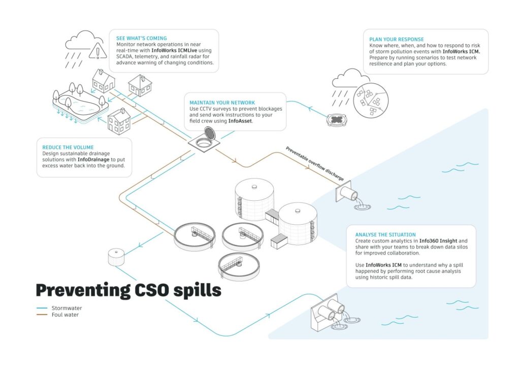
💡 Are you focused on combatting CSOs (Combined Sewer Overflows) or do you use Civil 3D and need to collaborate with other teams or on multiple projects across sites? We have an article that can help you identify your essential use cases.
Core concepts in hydraulic modeling
- Hydraulic Grade Line (HGL)
- Critical duration
- Backwater effects
- Flow regime
- Mesh resolution (2D)
How hydraulic modeling works
The process of performing hydraulic modeling is usually composed of these steps:
- Data collection
- Network construction
- Parameter assignment
- Boundary conditions
- Simulation
- Calibration and validation
- Scenario testing
- Reporting
Common mistakes in hydraulic modeling
- Incorrect boundary conditions
- Unrealistic roughness values
- Poor mesh design
- Ignoring critical duration
- Misinterpreting results
Advanced modeling and digital twins
Modern hydraulic modeling allows engineers to:
- Build integrated 1D and 2D models
- Simulate real-time system behaviour
- Incorporate SCADA data
- Predict future conditions
Going further and becoming more detailed in this work eventually leads water utilities to pursue digital twins systems that support proactive decision-making.
Frequently asked questions about hydraulic modeling
What is hydraulic modeling?
Hydraulic modeling is the simulation of how water flows through systems such as pipes, rivers, and surface floodplains.
What is the difference between hydraulic modeling and hydrology?
Hydrology focuses on rainfall and runoff, while hydraulics focuses on flow through systems.
What is 1D vs 2D hydraulic modeling?
1D models simulate flow along a path, while 2D models simulate flow across surfaces.
What is integrated catchment modeling?
It combines rivers, drainage, and surface flow into one model.
Why is hydraulic modeling important?
It supports flood risk management, infrastructure design, and climate resilience, which is becoming increasingly important, particularly around the issue of water scarcity.
What software is used for hydraulic modeling?
Engineers use tools that simulate rivers, drainage systems, and surface flow together. Our customers primarily use InfoWorks ICM, although it can also be used in conjunction with HEC-RAS in integrated workflows.
Explore integrated hydraulic modeling solutions
- Autodesk offers one platform for every catchment, with many options for hydraulic modellers, including three options for InfoWorks ICM: Sewer, Flood, and Ultimate.
- We have a wealth of training content, including video courseware that is free for all to access with an Autodesk account.
- We publish a Storm, Sewer, Flood roadmap that details our current and future plans for InfoWorks ICM.