Urban drainage is undergoing a fundamental transformation around the world. As cities expand and climate patterns become more extreme, traditional drainage strategies, which are focused almost exclusively on collecting and evacuating stormwater, are proving increasingly inadequate. Capacity constraints, water quality impacts, energy consumption, and flood risk are forcing engineers and planners to rethink how urban water is managed.
Across Europe, particularly in Spain, this shift is being reinforced by evolving regulations that emphasize hydrological viability: the idea that urban development should not negatively impact the natural water cycle, either in terms of quantity or quality. In this context, Sustainable Urban Drainage Systems (SuDS) are no longer optional innovations. Rather, they are becoming essential components of resilient, future-ready cities.
For Green Blue Management (GBM), part of the TYPSA Group and one of Spain’s pioneers in SuDS design, meeting these challenges requires more than adopting green infrastructure. It requires a modeling approach capable of integrating SuDS with conventional drainage networks, validating performance under real conditions, and supporting informed decisions throughout the life of a project.
Designing Fuenlabrada Fairground Park
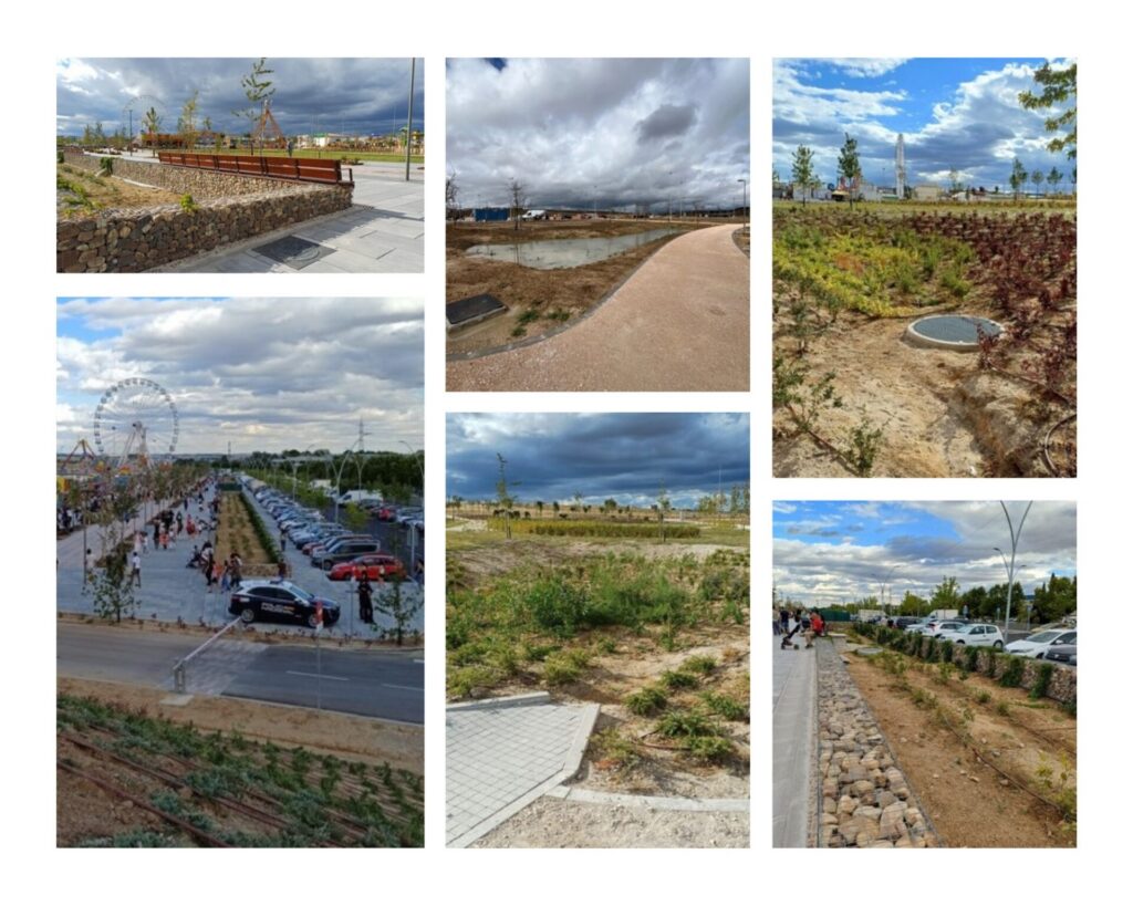
These ideas came together in the design of the Fuenlabrada Fairground Park, a newly constructed 19-hectare public space in the Madrid metropolitan area. From the earliest conceptual stages, drainage was treated as a core design driver, on equal footing with landscape, accessibility, and public use.
Rather than relying on a single downstream outlet or large detention structure, the project team envisioned the park as a distributed system capable of managing runoff at its source. The strategy was built around four key SuDS design principles:
- Runoff quantity control: prioritizing infiltration and on-site storage
- Water quality treatment: addressing pollutants mobilized during storm events
- Landscape integration: ensuring SuDS features contributed positively to public space
- Green infrastructure: enhancing biodiversity and ecosystem services
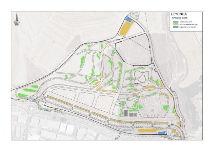
The resulting design incorporated rain gardens, bioretention areas, vegetated swales, and infiltration basins distributed throughout the site. These elements were intentionally interconnected. When one feature reached capacity, excess water would flow via controlled surface pathways or underground pipes to downstream SuDS located at lower elevations.
“The goal was for the park to behave like a sponge,” explains Miguel Rico, Production Director at Green Blue Management. “Instead of pushing water out of the site as quickly as possible, we wanted to retain, slow, and infiltrate it across the entire system.”
These SuDS elements were fully integrated into the park’s landscape and daily use. They do not interfere with events, pedestrian circulation, or maintenance activities, demonstrating that sustainable drainage can enhance, rather than constrain, urban spaces.
Why integrated modeling was essential
Designing a system with dozens of interconnected SuDS elements, each with its own geometry, materials, infiltration behavior, and overflow relationships posed a significant modeling challenge.
GBM needed a tool that could:
- Accurately reproduce hydrological processes within SuDS elements
- Combine surface flows, surface overflows, and underground pipe networks
- Support dynamic, time-based simulations rather than static calculations
- Allow rapid iteration as designs evolved or construction conditions changed
- Provide clear visual validation of connectivity, elevations, and performance
- Integrate with AutoCAD and Civil 3D to support BIM workflows
To meet these requirements, the team selected Autodesk InfoDrainage.
“Static, element-by-element calculations are no longer sufficient for systems like this,” says Rico. “We needed to understand how the entire network behaves dynamically, during real rainfall events.”
From conceptual strategy to detailed digital model
Before any hydraulic simulations were performed, the team invested significant effort in conceptual drainage design, a step Rico considers critical to project success. SuDS locations, typologies, and interconnections were defined early, alongside topographic shaping to ensure runoff could reach each feature naturally.
Once this framework was established, InfoDrainage was used to build the detailed digital model. Topography was imported from georeferenced point-cloud data, while SuDS layouts, basins, and pipe networks were brought in from AutoCAD files.
One of the most powerful features for this project was InfoDrainage’s ability to create custom templates. Although the park contains many SuDS elements, only a few typologies are repeated throughout the site. By defining typical rain garden and bioretention sections, including geometry, material layers, porosity, infiltration rates, and overflow structures, the team could rapidly generate dozens of consistent, data-rich elements.
“In a matter of minutes, we were able to populate the model with nearly 50 rain gardens, all with the correct geometric and hydraulic properties,” Rico notes. “That level of efficiency is essential on projects of this scale.”
Testing storms, not assumptions
Traditional drainage design often relies on identifying a single “critical storm” based on catchment concentration time. However, systems that include significant storage and infiltration behave differently. The critical condition is not always obvious and can vary from one SuDS element to another.
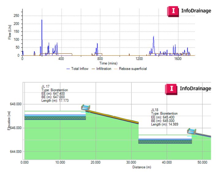
To address this, the team adopted an approach commonly used in the UK and other markets: simulating a battery of rainfall events with varying durations and intensities. For the Fuenlabrada project, storms ranging from 10 minutes to 12 hours were analyzed, based on locally developed intensity-duration-frequency curves.
This approach revealed that:
- Different SuDS elements reached critical conditions under different storm durations
- Upstream-downstream interactions significantly influenced performance
- System-wide behavior could not be inferred from isolated calculations
Using InfoDrainage’s dynamic simulations, the team was able to visualize water levels, inflows, outflows, infiltration rates, and surface overflows at every time step, effectively watching how the system responded as a storm unfolded.
“At that point, you’re no longer guessing,” says Rico. “You can see exactly where water is stored, where it flows, and how long it takes to empty.”
When results were aggregated at the park scale, the benefits of the integrated approach became clear. The model demonstrated that:
- Design storms are managed without uncontrolled flooding
- Ordinary rainfall events are largely retained on site
- During extreme events, peak discharges remain below pre-development flows
These outcomes align with Spain’s updated public hydraulic domain regulations, providing a strong technical basis for approval and long-term confidence.
Supporting construction and real-world validation
The role of the model did not end at design. As construction progressed, InfoDrainage allowed the team to update material properties, infiltration rates, and connections as more information became available, ensuring the model remained aligned with on-site reality.
In addition, observed rainfall data from nearby gauges was used to simulate real storm events. By comparing modeled behavior with field observations such as water depths and emptying times, the team was able to perform a qualitative validation of system performance.
“This ability to contrast design assumptions with real behavior is incredibly valuable,” Rico explains. “It gives confidence not only during construction, but for long-term operation.”
For GBM, the Fuenlabrada Fairground Park illustrates a broader lesson for the water sector.
“When SuDS are designed as part of an integrated system and supported by rigorous modeling, they stop being seen as experimental or decorative,” says Rico. “They become reliable infrastructure.”
As climate pressures intensify and regulatory expectations evolve, modeling tools like Autodesk InfoDrainage are helping engineers move beyond compliance toward genuinely resilient, water-sensitive urban design – where green infrastructure, conventional drainage, and digital workflows work together from concept to construction and beyond.
Hear directly from GBM
Sustainable Urban Drainage Systems (SuDS) are no longer a “nice-to-have”. They’re quickly becoming essential to urban resilience as cities grow ever larger and extreme rainfall becomes more frequent. In this Spanish-language webinar, Autodesk Water Infrastructure and Green Blue Management walk through how hydraulic modeling helps teams integrate conventional drainage networks and SuDS from the earliest design stages through construction. The session includes a real, built case study of Parque Ferial de Fuenlabrada, an extensive new development outside of Madrid.
Turn on auto-generated subtitles for English and other languages. No time to watch? We put together 3 takeaways from the webinar. 👇
The 3 big takeaways from the webinar
1. SuDS work best when they’re designed as a connected system – not as standalone features.
One of the strongest messages from the webinar is that SuDS deliver the most value when they are planned as part of an integrated drainage strategy alongside conventional pipes, manholes, and inlets. In the Fuenlabrada project, SuDS elements (rain gardens, bioretention areas, vegetated swales, infiltration zones) were coordinated so that when one element fills, controlled surface overflows route water to downstream SuDS, distributing storage across the whole site, helping the park behave “like a sponge.”
2. Dynamic modeling is essential for modern drainage because storms don’t behave like static design checks.
Blue Green Management contrasted traditional “static” approaches (checking pipes one-by-one) with dynamic simulation, which shows how the whole network responds over time – more like a movie than a snapshot, as they note. This matters especially when you introduce storage and infiltration (lamination/attenuation, percolation through filter media, infiltration to native soils, controlled overflows). The result is better insight into where and when issues occur, and faster iteration when you need to adjust slopes, diameters, connections, or SuDS parameters.
3) The model shouldn’t stop at design – use it during construction and even against real rainfall events
A practical and very compelling point: the team used modeling not just for design approval, but also to support construction follow-up. As material properties or site conditions change (eg, updated permeability tests, revised connections), the model can be quickly updated across selected assets or groups of SuDS. They also describe simulating observed rainfall from a nearby rain gauge and comparing results qualitatively with field observations. This built confidence that the system was behaving as intended and supporting defensible decisions.
Do deeper into SuDS
- We’re big fans of SuDs and have articles about all of the SuDS features inside InfoDrainage detailing how they work, including rain gardens, bioretention systems, swales, infiltration trenches, cellular storage, porous pavement, soakaways, and wet ponds and infiltration basins.
- Do you follow CIRIA’s guidance for SuDS? Download a copy of our CIRIA 753 SuDS manual for InfoDrainage.
- New to drainage design? Watch our ‘Fundamentals of Drainage Design’: a framework with 8 steps video.
- Try InfoDrainage yourself by downloading a free trial for 30 days (no credit card required). Are you a student or educator? You can use our water software for free.