We are pleased to spotlight guest author Mariya Bodylevskaya, who discovered InfoDrainage in the course of her studies around sustainable drainage at HFT Stuttgart. She shares her experience building a framework for better understanding and evaluating the performance of bioswales in urban environments.
For several years, I have studied the topic of Sustainable Drainage Systems (SuDS) as part of the Smart City Solutions program at HFT Stuttgart, analyzing case studies – mostly from the United States and Europe – to assess the predicted effectiveness of SuDS and to understand how they should be designed to achieve specific performance goals.
When I began my master’s thesis as part of the Smart City Solutions program, my aim was to go beyond theory. I wanted to determine whether sustainable drainage strategies could be applied to a real-world urban site and to assess how a proposed solution would perform before the first drop of rain fell. But, of course, the true effectiveness of such solutions can only be assessed after a heavy rainfall – which we can do by utilising a representative digital model.
This work, Proposing and Demonstrating a Toolbox for Designing Bioswales and Evaluating Their Impact on Sustainability Using BIM: A Case Study in Stuttgart, became a framework for exploring both the design and the performance assessment of bioswales in real urban contexts. My goal was clear: to create a practical toolbox for designing SuDS elements, particularly bioswales, and for evaluating their effectiveness.
Defining the approach
The first step was to define the approach and identify the most suitable methods and tools to turn this idea into a working solution capable of delivering results already at the design stage.
In my search for suitable methods and software, I discovered InfoDrainage, Autodesk’s Civil 3D-friendly application for simulating SuDS. It enables the evaluation of engineering solutions before they are implemented on-site. I used Civil 3D to model the site’s terrain and geometry, and this combination formed the foundation of my methodology.
That’s how I shaped the structure of the research: driven by a real site, with a strong focus on applicability, and a self-directed approach to mastering digital design tools.
Why are bioswales so important?
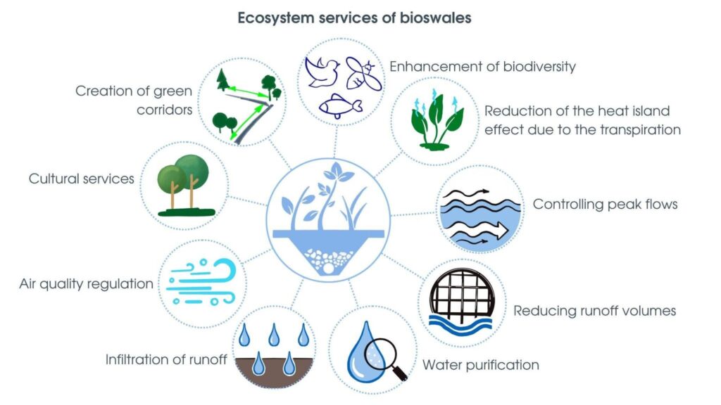
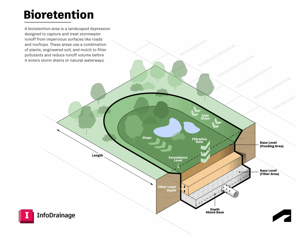
As a landscape architect, I’m interested in all nature-based solutions. But in this project, I chose to focus on a single element: the bioswale. This decision was driven both by the characteristics of the site and the ecosystem services that bioswales provide. They are particularly effective at reducing surface runoff – especially along roads and parking lots – often outperforming other SuDS elements in these contexts.
I deliberately chose a site I knew well: the area around HFT Stuttgart, where I was studying. After every rainfall, I would see large puddles blocking access to the nearby park. I wanted to improve this space.
The goal: A practical SuDS toolbox
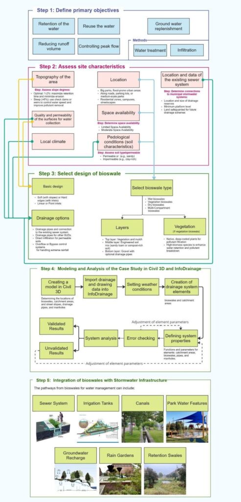
The goal of my research wasn’t just to simulate a bioswale, but to develop a practical toolbox for designing sustainable drainage features within real-world urban conditions.
This toolbox functions as a step-by-step guide, including:
- Defining the project objectives (filtration, peak flow reduction…)
- Site analysis (soil type, slope, drainage system, climate…)
- Geometry design using Civil 3D
- Hydrologic simulation in InfoDrainage
- Performance evaluation and result interpretation
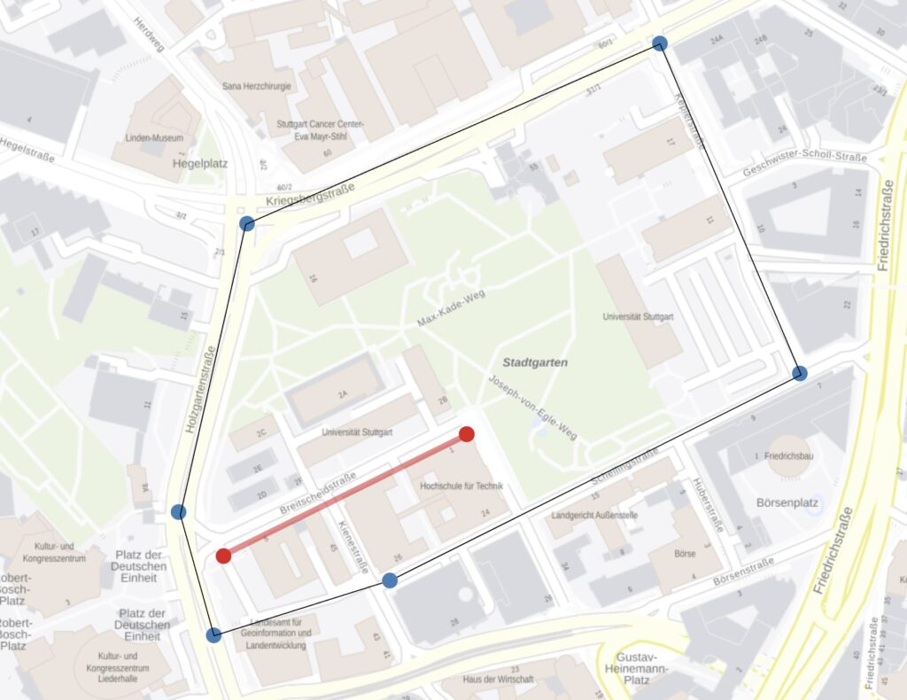
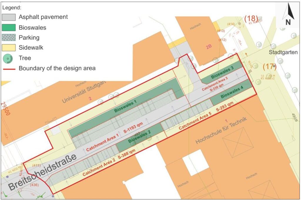
The project site is located on Breitscheidstraße in Stuttgart, which is bounded by four surrounding streets. I placed four bioswales across the area, each integrated into the existing infrastructure – along a road, near a sidewalk, or replacing a parking space. Their locations were determined by surface slopes and expected water flow. Functional zoning was applied to the site. Roads and parking areas were combined into a single zone, separated by bioswales from the pedestrian and recreational areas. This clear separation helps improve stormwater management and enhances pedestrian comfort.
I created a digital terrain model in Civil 3D, including roads, stormwater networks, manholes, and pipes. Then, in InfoDrainage, I defined a heavy rainfall event (35 mm/h over 6 hours) and simulated how water would behave within the system.
How the simulation was performed
The InfoDrainage simulation allowed me to flexibly adjust parameters, test design alternatives, and reach the desired outcomes. I also ran a comparative simulation – with and without bioswales – to evaluate the impact.
Key results:
- Peak flow was reduced from 9.7 to 3.1 L/s
- Runoff volume decreased by 42%
- Outflow from the bioswale began 100 minutes after rainfall started
- No flooding was recorded — the system handled the rainfall without being overloaded.
Further insights were provided by the simulation graph generated in InfoDrainage.
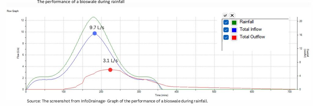
It showed three key curves:
- Blue: total inflow into the system
- Red: total outflow from the bioswale
- Green: rainfall intensity
The red curve is clearly shifted to the right compared to the blue and green lines: outflow starts only after 100 minutes and continues until minute 680, even though rainfall lasted only 6 hours. This indicates that the bioswale not only reduces peak flow, but also extends the time of discharge, flattening the pressure on the system.
The contrast in peak values is also clear:
- Peak inflow: 9.7 L/s
- Peak outflow: 3.1 L/s
In short, bioswales achieve the core SuDS goals: delaying peak flows, reducing overall runoff, and buffering water release over time. That was the key objective of my research. The simulation clearly demonstrates how the bioswale absorbs, slows, and directs stormwater, improving overall runoff management and reducing stress on the drainage network.
Additional outcomes and reflections
Even when connected to conventional drainage systems, bioswales play a vital role: they help regulate, filter, and redirect water, making infrastructure more resilient. At the same time, they enhance the urban environment with seating areas, greenery, and visible water elements that celebrate, rather than hide, stormwater. This approach raises public awareness of sustainable infrastructure, fosters urban biodiversity, and helps link parks and green spaces into coherent ecological corridors.
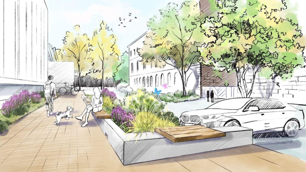
One bioswale in my project was designed as a student seating zone – offering a place to rest and observe the landscape after rainfall.
Why this matters
The 2021 floods in Germany, which claimed more than 220 lives across Europe, were a stark reminder that traditional drainage systems are increasingly inadequate when faced with extreme weather events and growing urban pressures. SuDS are essential engineering solutions that enhance urban resilience while integrating ecological and social benefits.
Digital design allows us to anticipate risks, optimize parameters, and avoid failure. The synergy of Civil 3D + InfoDrainage with ecosystem-based thinking represents the future of urban water management.
What’s next?
The toolbox I developed can be adapted to different sites and climate scenarios. I see its potential for use by landscape architects, civil engineers, and urban designers – particularly on university campuses, for street retrofits, and around post-industrial areas.
A next step might be to explore water filtration across different soil types, and to integrate regional climate data into my InfoDrainage models. In my thesis, I reflected on an additional idea – diverting a portion of stormwater away from the municipal drainage network and managing it entirely on-site. Details of my work and further context on this concept are available in my Master thesis via the OPUS portal.
The city of the future is green, digital, and adaptive – a place where technology and nature operate in harmony to create resilient and liveable environments. Every landscape architect has the opportunity to contribute to building this synergy.
Wade deeper into SuDS
- Do you use SuDS in your work? Download Autodesk’s Guide to Representing SuDS in InfoDrainage.
- Want to try InfoDrainage yourself? We offer a free trial with no credit card required. Are you a student or educator? You can use our water software for free.
- Read our articles about bioretention areas, cellular storage, porous pavement, swales, and infiltration trenches, which have some nice illustrations that we encourage you to share whenever you need to explain how SuDS work.